Course:GEOS303/2023/Guyana
Introduction to Guyana

Guyana is located in the Northeast part of South America[1] and is composed of almost 87% forest cover over the landscape of 214969 km squared. Guyana's population is comprised of over 78500 Indigenous people, making up the majority of those who reside in the rainforest and rely on the rich biodiversity.[2] The Iwokrama is Guyana's largest forest, spanning about 1 million acres across the Guinean Shield, an ancient geological formation which harnesses a vast portion of the worlds diversity [3]. With this in mind, the government of Guyana has recognised the importance of protecting its natural resources and therefore has established suitable measures to protect their precious environment. Some of these measures include the development of a Low Carbon Development Strategy (LCDS) to mitigate the impacts witnessed from climate change [4].
Climate and biomes
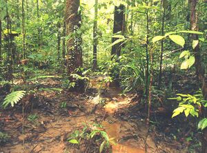
Dominant biomes and ecoregions in Guyana and their climatic and geographic characteristics:
The Tropic region of Guyana is home to a variety of biomes and ecoregions from: Tropical Rainforest, Moist Broadleaf Forest, Grassland, Savanna, and Shrubland. [5]. While the Guiana Shield maintains a strong portion of the Amazon Basin, the interior of Guyana is an abode to vast mountainous regions and savannas[6].
Guyana's climate is dependent on the region as regions along the coast are more humid and warmer than the interior along with cooler temperatures in the mountainous regions in the South.[7] The average temperature of Guyana's wet tropical climate ranges from 16 - 34 degrees Celsius. The lower temperatures are found in the higher mountainous regions whereas along the coast the average levels off between 21 - 31 degrees Celsius. The coastal temperatures differ from the interior due to a stabilizing effect created by the sea and trade winds[8].
Overall, in the equatorial lowland regions there are small seasonal differences and is humid with high temperatures and rainfall. Guyana undergoes two wet seasons throughout the year from April to August and then again in December into February. Annual rainfall ranges between 70 - 90 inches (1800 and 2200 mm). During the months of July to August Guyana is vulnerable to seasonal droughts which are dependent on that year's trade wind movement.[9]
Tropical Rainforest:
The dominant biome covering most of the landscape is the Tropical dense rainforest, spanning across the highland region of Guyana and is one of the largest continuous pristine lowland tropical rainforests globally. The forest itself can grow up to 40 m in multilayers to support the high species richness of Guyana, hosting over 786 bird species and 80000 vascular plants with over 50% endemism. [10]
Tropical/Sub-Tropical Moist Broadleaf Forest:

This moist forest ecoregion is situated in South Guyana in the Guianan Highlands. The climate found in this montane landscape ranges from humid to sub-humid and an average temperature of 24 degrees C. The moist broadleaf forest of Guyana consists of a landscape of metamorphic and igneous rock, resulting from a variety of geologic events that occurred overtime. This portion of the Guiana Shield [11]
Grassland/Savanna:
Found in the South of Guyana and spanning throughout Brazil, Venezuela, and Suriname is the Guinean Savanna. This ecoregion consists of a patchwork of tree-covered and treeless areas along rolling upland plains and sandy slopes within the Guinean Shield.[12]
Shrubland:
An ecoregion along the flat plains of Guyana with a 20 - 70% grass layer coverage. Shrubs in these areas dominate herbaceous layers due to moisture and nutrient availability.[13]
Diversity
Overview of Biodiversity:
Guyana's forests make up 85% of the total land area making it home to some of the world's most intact rainforests full of ecosystems teeming with biological diversity. [14] Within the Guiana Shield in which Guyana is a part of, there are over 8000 species of fauna and approximately 1,800 species of amphibians, birds, reptiles and mammals of which 50% are endemic [14]. Guyana’s biome, environmental characteristics and climate make it ideal for speciation and additionally have generally low sociological and environmental pressures which threatens the survival of species [15]. Guyana’s impressive biodiversity continues growing every year, with new species continuously being identified [15]. Guyana's unique diverse geography, with towering mountains and grassland savannas creates ideal environments for high levels of endemism [16] and promotes biological diversity [17].
Botanical & Tree Diversity:
Guyana forests feature over 1000 species of trees [18]. Early botanists who studied the plant diversity of Guyana identified two forest types in the region: “forests of the swamp lands” and “forests on the slightly elevated or hilly lands”, now referred to as mixed forests and floodplain forests and categorized fauna diversity accordingly [19]. Forests of the swamp lands, now more commonly referred to as the floodplain forests are largely dominated by Mora excelsa also known as the mora tree, while mixed forests don’t have one dominant species, rather a plethora of various dominant tree species such as Lecythidaceae, Chrysobalanaceae, Alexa imperatricis, and Catostemma commune [19]. Tree diversity varies significantly depending on region and Guyana’s forests have evolved to be diverse in part due to a lower rate of disturbance, allowing for conditions of survival and continuation. These forest regions house the region's 6500 species of plants [20].
Mammal, Bird and Reptile Diversity:
4% of the world's animals live in Guyana such as the jaguar, giant river otter, harpy eagle, Brazilian tapir, giant anteater and giant armadillo [16]. Many of these species live within the Guiana shield, including 1004 species of birds (8% endemic), 282 species of mammals (11% endemic), 269 amphibians (54% endemic), and 295 reptiles (30% endemic) [21].
Evolution & Endemism:
Due to Guyana’s geographical isolation, it is home to a high percentage of endemism. Over 50% of species in Guyana are endemic, meaning that they are only found in that unique region [14]. Examples of Guyana’s endemic species include the golden rocket frog, Carapa akuri, Ischnocolinae [22], new river tree frog, gonatodes timidus, stejneger's worm lizard, The Sinnamary brush-tailed rat [23].
The mountainous regions of Guyana have been found to have the highest endemism in the country, specifically, the Pakaraima Mts. Region (11). This is due to the altitudinal species-richenness, suggesting that with higher altitude the more endemic species exist [24].
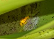 - Endemic species of Guyana - Golden Rocket Frog/
Human influences
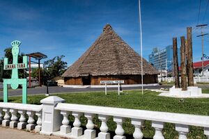
The role humans historically have played in shaping the ecology of the dominant ecosystems in Guyana:
The human impacts within the tropical region of Guyana are varied and have risen over millenia, shaping the ecology within the country significantly. Prior to colonisation in the late 1700s by the Dutch [25] , humans (the indigenous populations of Guyana) have occupied and have been shaping and configuring the land which has modified the interactions of plants/animal species. This is one of the most prominent features for the indigenous groups,[26] altering the distribution of plant and animal species through the implementation of traditional agrarian and plant control practices [27]. Some specific examples include the biodiversity conservation of the, 'Wai Wai Indigenous people of the Kanashen Village[28],' practising the controlled burning of savannas to preserve the ground for farming and hunting practices clearing out dead infertile organic matter [29] [30]. With specific reference to this village, it was declared and recognized as a Community Owned Conservation “Protected Area” in 2007 whereby there is a clear management hand to uphold traditions and preserve biodiversity. The implementation of indigenous-led conservation has resulted and will continue to result in greater sustainability and stability for Guyana’s forest ecosystems and biodiversity [31] .
The impacts and approach from colonial settlers were very different from that of the Amazonian people and ignored these traditional practices which have been proven to have better preserved ecology and biodiversity [32]. A legacy left behind from Guyana’s Colonisation was that of fire suppression which has had ghastly ramifications for ecosystems and the fire dependent ecologies which are so greatly abundant in Guyana’s Tropical Savanna ecosystem [29] . As seen from Table s1 (b) from the MRVS (Monitoring Reporting and Verification System) Report from 2021 - a framework developed to monitor, evaluate and announce the implications deforestation has on carbon emissions in Guyana, [33] the data indicates there is still a great amount of exploitation of forest resources which is shaping the ecology of the dominant ecosystem. For 2021, the total emissions as a result of deforestation was 8,464,665 t CO2. The Drivers of these CO2 emissions included, "Mining, Mining infrastructure, Forestry Infrastructure, Infrastructure, Agriculture, Settlements, Fire and Shifting cultivation."[33] The Gold and diamond industry today in Guyana account for one of their main exports. Exploitation of these resources has seen a significant increase of around 35% since the 1990s whereby logging authorities now cover around 40% of the country. Alongside this, 11.4 million acres have been made available to intercontinental cooperations [34].
Breakdown of the impacts on the Ecology in Guyana post-colonisation.
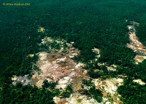
Summaries from Lewis and Rosales (2020)[35] have stated the extent and nature of the human influences and the ramifications on ecology and biodiversity, whereby, they have broken the impacts down into varying categories being: 1. Deforestation impacts, 2. Forest Fragmentation, 3. Landform and Soil Alterations and 4. Loss of Soil Connectivity.
1. The deforestation which is occurring in Guyana causes forest fragmentation and this alters the species interactions between animals and plants. From retrievable data taken using tree cores and ethnographic data [27], it has been concluded that, the total forest emissions from degradation was around roughly 52% [36] indicating that they have been influenced by anthropogenic behaviour[27]. Deforestation also reduces the important carbon sequestration process' forests provide in managing climate. [37]
2. The Fragmentation of forests mentioned above, has implications on the global and local scale whereby the habitat connectivity decreases, and biodiversity is therefore impacted. Lewis and Rosales state that dispersal mechanisms are altered and therefore species are located in broken up habitats. The traditional lands from the Ameridian people have been quoted to have been squeezed whereby colonial endeavours meant mining practices covered the traditional lands. This has in turn caused shortages of resources .[38]
3. There has been soil alterations and landform changes as a result of the land use changes, mining etc and these changes have meant soil profiles are disturbed which has knock on effects seen with phenological changes and cascading ecosystem interactions. The environmental degradation has predominantly resulted from that of mining activities and deforestation whereby rivers have been silted and contaminated by mercury [39]. The toxic element Mercury is of great concern and estimations state that 49.37 metric tonnes have been transmitted into our environments which obviously has grave effects on marine ecosystems and water stocks [34]. Contamination of water-bodies and destruction of dominant ecosystems are key to the ecology in the region. These have both had knock on effects to the food chain with a rise in sediment concentration within water negatively effecting marine species [35].
4. Lastly, the loss of connectivity indicates that dispersal mechanisms resulting from the human alterations to the ecosystem have become more difficult for native species. This poses the serious problem of extinction in future years [40][35].
The Future for biodiversity in Guyana:
The future and exposure to future threats on biodiversity could go either way in Guyana with an emphasis being placed on conservation, yet there is an argument to be made about the economic benefits logging, mining and further development bring [35]. Over the past 22 years, conservation efforts from the United Nations climate change agreements have implemented frameworks such as the REDD + which stands for, “Reducing emissions from deforestation and forest degradation in developing countries”, with the + being specifically related to the amplification of forest carbon stocks [41] hence ecology is being greater protected through provisions such as the REDD +.
A region of Guyana steeped in Indigenous histories and traditions is North Rupunui District in the south western part of Guyana. This is a highly biodiverse area brimming with terrestrial and aquatic habitats, where the Makushi and Wapishana peoples live and benefit from the and high level of biodiversity. However, a study done by Jayalaxshmi et. Al (2008) states that there is a high amount of uncertainty for the future of highly biodiverse regions like this in Guyana as a result of exploitational activities such as logging, mining and hunting as ecosystems could potential be subject to cascading effects [42]. The Yupuka Village community have been noted to have large amounts of biodiversity (53% of the country’s bird species reside there). Projects there have encouraged protection for aquatic species which are essential to the food chain and indigenous communities such as black caimans and turtle porridge where subsistence level hunting and practices are encouraged [43]. Projects like these are essential for the conservation of biodiversity for present and future evolution of species and ecosystems.
The future for biodiversity and conservation projects as mentioned above, could be compromised. As a result of the further development plans mentioned such as a Guyana to Brazil railroad network for example, would undermine the traditional conservational strategies and ecosystems and fragment Ameridian indigenous territories [38].
Conservation
Marine Spacial Planning - World Wildlife Fund (WWF)
A four-year marine spacial planning project was funded by the European Union from July 2017 until December 2020 [44]. Focusing on coastal and marine resources, with hopes of gaining more governance and protection, this project focuses on achieving Aichi biodiversity targets set by the United Nations. The goal of this project is to gain knowledge of the area and how stakeholders interact with the marine environment by creating spatial data. This project uses a participatory approach. Indigenos peoples and gender are noticed as marginalized groups and ensured their needs will be considered while balancing the needs for maintaining biodiversity and ocean health and having a successful economy. The idea is that the knowledge gained through this participatory approach can be used to identify marine and coastal areas which would benefit from conservation status. Approaching the challenge with the participation of stakeholders like industry, government and local communities, creates active participation from those impacted by the decisions made. Guyana has 0.02% marine protected area coverage of the 136,910km2 of marine coastal area [45]. The knowledge gained from this project can provide insight on how climate change is altering ecosystems and species distributions and provide insight into whether these protected areas are beneficial or if alternate conservation status needs to be considered [46].
Low Carbon Development Strategy (LCDS) - Government of Guyana
The LCDS focuses on sustainable economic growth based on ecosystem services, specifically provided by their forests [47]. Guyana's forests have an estimated yearly value of 40-50 billion dollars US. However, deforestation due to mining, agricultural practices, and infrastructure, currently provide jobs and economic gain making the potential future loss of ecosystem value to be overlooked. Since 2009, Guyana has been working to find a strategy which balances economic gain and sustainable forest use with the most recent project being the LCDS 2030. It aims to incentivize global development towards valuing the world's ecosystem services through public and private finance. The four main goals adapted from the national consultation based on the 2009 LCDS are to "align with global climate and biodiversity goals, protect against climate change and biodiversity loss, invest in clean energy and stimulate low carbon growth, and value ecosystem services". Low carbon development in Guyana is approached through methods like preventing and managing waste, developing low carbon infrastructure and working towards sustainable homes and communities. The 2030 LCDS is said to have promoted the inclusion of women and vulnerable groups like youth by awarding Low Carbon cash grants, providing jobs to indigenous women, providing laptops for access to social services, and offering training to women to monitor the resources needed to protect mangroves from rising sea levels. The project is still far from reaching its goals for conservation but has come a long way in improving social outcomes since the original 2009 LCDS.
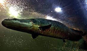
Community Based Management of Arapaima gigas
Arapaima are the largest scaled freshwater fish in Guyana, explaining the appeal that led to overfishing and their population's decline [48]. From 1986-1988 the IUCN Red List had this species listed as "Vulnerable" and now in 2023, it is currently labelled as "Data Deficient" [48][49]. Arapaima gigas used to be associated with many taboos in the Makushi culture claiming that if people ate this fish, they would get sores, scales or be electrocuted by lightning [50]. Despite the lack of strong belief in these traditional taboos, the community decided to put in effect social pressures which now help maintain healthy population sizes. Judgement from the community now replaces the original fear of the harm you would face following consumption of this species. In 2000, a temporary ban on fishing of Arapaima was put in place [48]. However, due to the lack of enforcement, poaching is still a concern regarding population declines. The local communities decision to go back to their original ways of successful conservation occured while additional community-based management programs are being put in place [48] [50]. Different regions which are more easily accessible to poachers require more focus as larger amounts of harvesting are occuring. Yearly mortality rates of 62-72% suggest that illegal harvesting is still a current issue [51]. Although Arapaima are also found in Brazil, it is suggested to hold off on translocations into Guyana waters as genetics of the populations have not been researched enough to confirm if they are the same species [48]. In 2016, low genetic diversity was found in populations in the Essequibo and Branco river basins. Microsatellite markers showed more genetic differentiation between populations at further geographic distances. However, if they are separate species, negative consequences may occur with hybridization. The conservation efforts for Arapaima in Guyana are ongoing with more information on the populations genetics between populations potentially leading to more effective methods [48]. Although social mechanisms have not completely diminished the concern for Arapaima population sizes, they are currently proving to be more effective than the government projects.
Iwokrama International Centre (IIC) for Rainforest Conservation and Development
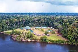
The IIC is a not-for-profit organisation established in 1996 [52]. This rainforest reserve of 371,000 hectares is meant to provide social and economic benefits while still conserving and protecting the ecological integrity of the area. The IIC works with the Government of Guyana and international partners to gain income from eco-system services. It is trying to challenge the idea that humans must be separate from nature in order for it to be sustainable by having part of the area act as a wilderness preserve and the other as an area for resources to be used sustainably. The Iwokrama International Centre includes protected areas for terrestrial and inland water environments [45]. The people of Guyana are meant to gain social benefits through sustainable ecotourism, sustainable forestry, monitoring, science, and research. In 2022 the Iwokrama River Lodge was one of the top 100 Green Destinations [52]. IIC has also supported youth through internships and has a research unit led by indigenous women who promote their traditional cultures in schools.
References
Please use the Wikipedia reference style. Provide a citation for every sentence, statement, thought, or bit of data not your own, giving the author, year, AND page. For dictionary references for English-language terms, I strongly recommend you use the Oxford English Dictionary. You can reference foreign-language sources but please also provide translations into English in the reference list.
Note: Before writing your wiki article on the UBC Wiki, it may be helpful to review the tips in Wikipedia: Writing better articles.[53]
- ↑ Steege, Jetten, Polak, Werger, H, V.G, A.M, M.J.A (1993). "Tropical rain forest types and soil factors in a watershed area in Guyana". Journal of Vegetation Science. Volume 4: 705–716.CS1 maint: multiple names: authors list (link)
- ↑ "Partner Countries Guyana". Norway's International Climate and Forest Initiative. 2023.
- ↑ "Iwokrama". Bradt Guides. 2023. Retrieved November 7th 2023. Check date values in:
|access-date=(help) - ↑ Convention on Biological Diversity. "Guyana - Main Details". Convention of Biological Diversity. Retrieved 29th November 2023. Check date values in:
|access-date=(help) - ↑ LAC Geographic (08/25/2022). "Guyana: Natural Landscape". Check date values in:
|date=(help) - ↑ Black, Wagner, Abbott, Jasmine E., Thomas, Geoffrey (June 2021). "Assessing Lignin Decomposition and Soil Organic Carbon Contents Across a Tropical Savannah-Rainforest Boundary in Guyana". frontiers. vol 4 – via JSTOR.CS1 maint: multiple names: authors list (link)
- ↑ "Guyana: Natural Landscape". Latin America and Caribbean Geographic. 08/25/22. Check date values in:
|date=, |archive-date=(help) - ↑ The World Bank Group (2021). "Country Guyana". Climate Change Knowledge Portal. Retrieved 10/05/23. Check date values in:
|access-date=(help) - ↑ Encyclopaedia Britannica, Inc (2023). "Climate of Guyana". Britannica. Retrieved 10/05/23. Check date values in:
|access-date=(help) - ↑ Schipper, Jan. "Guianan Lowland Moist Forests". one earth. Retrieved 10/07/23. Check date values in:
|access-date=(help) - ↑ The Editor (11/09/18). "Guianan Highlands Moist Forests Ecoregion". Latin America and Caribbean Geographic. Retrieved 10/07/23. Check date values in:
|access-date=, |date=(help) - ↑ The Editor (12/11/18). "Guianan Savanna Ecoregion". Latin America and Caribbean Geographic. Retrieved 10/07/23. Check date values in:
|access-date=, |date=(help) - ↑ Josse, C. (10/29/22). "Central Guianan Savanna & Shrubland". Nature Serve Explorer. Retrieved 10/07/23. Check date values in:
|access-date=, |date=(help) - ↑ 14.0 14.1 14.2 Environmental Protection Agency. "Fourth National Report to the Convention on Biological Diversity" (PDF).
- ↑ 15.0 15.1 Parkinson, Cindy (February 1, 2023). "Impressive biodiversity defines Guyana's vast forest ecosystem".
- ↑ 16.0 16.1 "Guyana". Rainforest Foundation US.
- ↑ E. Alonso, Leeanne. "Biodiversity Assessment Survey of the Upper Berbice Region Guyana" (PDF).
- ↑ "Overview Of Timber Sector Of Guyana". Timber Trade Portal.
- ↑ 19.0 19.1 van Andel, Tinde (October 2001). "Floristic composition and diversity of mixed primary and secondary forests in northwest Guyana".
- ↑ "Plant Diversity". Guyana Chronicle. May 8, 2011.
- ↑ Michael Snyder, Andrew (2018). "Biodiversity And Evolution In The Guiana Shield, South America".
- ↑ "Endemic Species In Guyana". May 1, 2022.
- ↑ "Endemic Animals of Guyana". Animalia.
- ↑ ter Steege, Hans (January 2000). "Flora, vegetation, endemism and altitudinal gradients in the Guyana Highland area: a brief overview".
- ↑ Khemraj, Tarron (2015). "The Colonial Origins of Guyana's Underdevelopment". Social and Economic Studies. 64: 151–185 – via JSTOR.
- ↑ Rostain, S. (2014). The Guianas: Pre-Columbian Heritage. In: Smith, C. (eds) Encyclopedia of Global Archaeology. Springer, New York, NY.[1]
- ↑ 27.0 27.1 27.2 Shah, Muna; Cummings, Anthony R. (2021). "An analysis of the influence of the human presence on the distribution of provisioning ecosystem services: A Guyana case study". Ecological indicators. 112: 1–11 – via ScienceDirect.
- ↑ Guyana’s National Protected Areas System (NPAS). "Kanashen Amerindian Protected Area". Protected Areas Comission.
- ↑ 29.0 29.1 Smith, Cathy; De Freitas, Kayla; Mistry, Jayalaxshmi (2023). "How global narratives shape local management: A history of fire in the tropical savannas of Belize and Guyana". Geographical Journal. 00: 1–14 – via Royal Geographical Society.
- ↑ Oakley, Elliott (2019). "'Opening Up' the Village". Etnofoor. 31 (2): 33–50 – via JSTOR.
- ↑ Janki, M., & Sose, C. (2008). 4.6 The WaiWai Protected Area - Our Land: Our Life. In K. Bosselmann, R. Engel, & P. Taylor, Governance for Sustainability Issues, Challenges, Successes (pp. 1-260). Gland: IUCN. [2]
- ↑ Fletcher, Michael-Shawn; Hamilton, Rebecca; Dressler, Wolfram; Palmer, Lisa (2021). "Indigenous knowledge and the shackles of wilderness". Perspective - Environmental Sciences. 118 (40): 1–7 – via PNAS.
- ↑ 33.0 33.1 Guyana Forestry Commission, 2021. Guyana REDD+ Monitoring Reporting & Verification System (MRVS) MRVS Report – Assessment Year 2021, s.l.: Guyana Forestry Commission. [3]
- ↑ 34.0 34.1 La Rose, Jean; MacKay, Fergus (2010). "Our Land, Our Life, Our Culture: The Indigenous Movement In Guyana". Visions of the Future: The Prospect for Reconciliation. 23 (4) – via Cultural Surivival.
- ↑ 35.0 35.1 35.2 35.3 Lewis, Susy; Rosales, Judith (2020). [10.4236/gep.2020.811003 "Restoration of Forested Lands under Bauxite Mining with Emphasis on Guyana during the First Two Decades of the XXI Century: A Review"] Check
|url=value (help). Journal of Geoscience and Environment Protection. 8: 41–67 – via Scientific Research. - ↑ Pearson, Timothy R H; Brown, Sandra; Lara Thelle, Murray; Sidman, Gabriel (2017). [10.1186/s13021-017-0072-2 "Greenhouse gas emissions from tropical forest degradation: An underestimated source"] Check
|url=value (help). Carbon Balance and Management. 13 (3): 1–11 – via ResearchGate. - ↑ Bosetti, Valentina; Rose, Steven K. (2011). "Reducing carbon emissions from deforestation and forest degradation: issues for policy design and implementation". Environment and Development Economics, Suppl.REDUCING EMISSIONS FROM DEFORESTATION AND FOREST. 16 (4): 357–360 – via ProQuest.
- ↑ 38.0 38.1 Griffiths, T. & Anselmo, L., 2010. Indigenous Peoples and Sustainable Livelihoods in Guyana: an overview of experiences and potential opportunities, Georgetown: Amerindian Peoples Association, Forest Peoples Programme and The North-South Institute. [4]
- ↑ Laing, T. (2018). Indigenous Peoples of Guyana. In Guyana’s REDD+ Agreement with Norway: Perceptions of and Impacts on Indigenous Communities (pp. 12–16). Center for Global Development. [5]
- ↑ Villard, Marc-André; Metzger, Jean Paul (2014). "Beyond the fragmentation debate: a conceptual modelto predict when habitat configuration really matters". Journal of Applied Ecology. 51: 309–318.
- ↑ "What is REDD+?". United Nations Climate Change. 2023. Retrieved 31st October 2023. Check date values in:
|access-date=(help) - ↑ Jayalaxshmi, Mistry; Berardi, Andrea; Simpson, Matthew (2008). "Birds as indicators of wetland status and change in the North Rupununi, Guyana". Biodiversity & Conservation. 17 (10): 2383–2409 – via ProQuest.
- ↑ Thompson, Akola (24th January 2019). "A community in Guyana relies on indigenous knowledge in conservation". Mongabay Series: Global Forests, Indigenous Peoples and Conservation. Retrieved 30th October 2023. Check date values in:
|access-date=, |date=(help) - ↑ "Marine Spatial Planning".
- ↑ 45.0 45.1 "Explore protected areas and OECMs". December 5, 2023.
- ↑ "Ocean governance and marine spatial planning: policy brief". December 6, 2023.
- ↑ "Guyana's Low Carbon Development Strategy".
- ↑ 48.0 48.1 48.2 48.3 48.4 48.5 Watson, Cynthia; Stewart, Donald; Kretzer, Annette (December 2016). "Genetic Diversity and Population Structure of the Threatened Giant Arapaima in Southwestern Guyana: Implications for Their Conservation". Copeia. 104: 864–872 – via JSTOR.
- ↑ "Red List Arapaima gigas".
- ↑ 50.0 50.1 Fernandes, Damian (2006). ""More eyes watching…" Community-based management of the Arapaima (Arapaima gigas) in Central Guyana". University of Manitoba electronic theses and practica. line feed character in
|title=at position 23 (help) - ↑ Watson, Cynthia; Stewart, Donald (November 2020). "Growth and mortality of the giant arapaima in Guyana: Implications for recovery of an over-exploited population". Fisheries Research. 231 – via ELSEVIER Science Direct. line feed character in
|title=at position 71 (help) - ↑ 52.0 52.1 "Iwokrama International Centre for Rainforest Conservation and Development".
- ↑ En.wikipedia.org. (2018). Writing better articles. [online] Available at: https://en.wikipedia.org/wiki/Wikipedia:Writing_better_articles [Accessed 18 Jan. 2018].
| This Tropical Ecology Resource was created by Course:GEOS303. |


