LFS:SoilWeb/Soil Management/Soil Erosion
Soil erosion is the detachment and transportation of soil particles by the forces of water and/or wind. It is a process that transforms soil into sediment. Sediment consists of transported and deposited particles or aggregates derived from rock, soil, or biological material.
Geological vs. Accelerated Soil Erosion
Geological erosion is a natural process that wears down topographic highs (hills and mountains) and fills in topographic lows (valleys, lakes and bays) through the deposition of eroded sediments.

Geological (or natural) erosion.
RELATED LINK:
|
Erosion that exceeds normal geologic erosion becomes destructive and is called accelerated erosion. This type of erosion occurs when the soil and natural vegetation are disturbed by human activity. Accelerated erosion is often 10 to 1000 times as destructive as geological erosion!

Accelerated (or human-induced) erosion.
Soils Susceptible to Erosion
Soils that are susceptible to erosion include:
- Soils with low water infiltration capability
- Soils with low organic matter content
- Soils with poor (unstable) structure
- Soils on steep hills (especially in regions of high rainfall)
- Soils with hydrophobic characteristics (usually intensified by fire)
Effects/Consequences of Soil Erosion
Soil erosion causes two main problems:
- Loss of soil productivity: When topsoil erodes, the less fertile and harder B horizon becomes exposed. This leads to lower forage production, lower water infiltration and greater runoff.
- Sediment pollution: When eroded sediment is rich in fertilizers or pesticides, it can upset the ecosystem not only at its point of deposition but in rivers and lakes many miles away. In addition, sediments may damage machinery, agitate respiratory problems and reduce visibility.
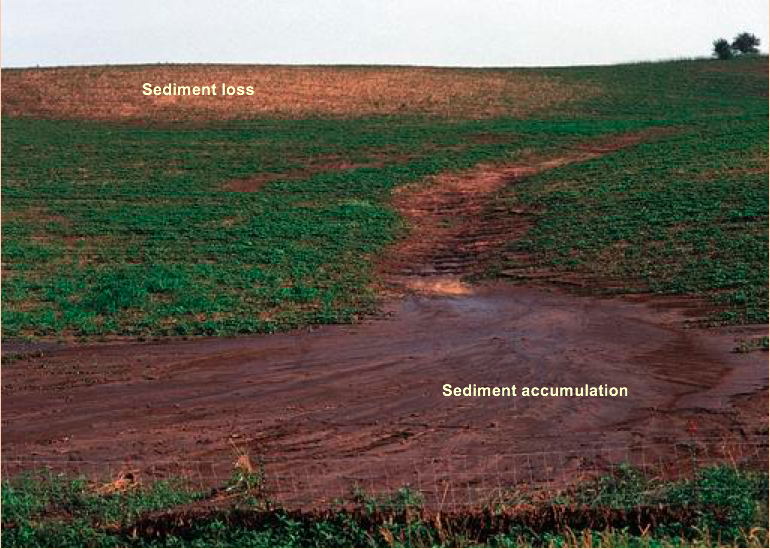
 Loss of productivity and sediment accumulating due to erosion sometimes can be seen in the same field as showing in this photo
Water Erosion
Mechanics
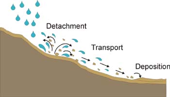
There are three steps to accelerated erosion by water:
- Detachment or loosening of soil particles caused by flowing water, freezing and thawing of the topsoil, and/or the impact of falling raindrops.
- Transportation of soil particles by floating, rolling, dragging, and/or splashing.
- Deposition of transported particles at some place lower in elevation.

Rain enhances the translocation of soil through the process of splashing. Individual raindrops detach soil aggregates and redeposit particles. The dispersed particles may then plug soil pores, reducing water intake. Once the soil dries, these particles develop into a crust at the soil surface and runoff is further increased.

Types of Water Erosion
There are three main types of water erosion:

- Sheet erosion: Relatively uniform soil removal by non-turbulent water (unchanneled surface runoff).

- Rill erosion: An erosion process on sloping fields where water concentrates in small channels, called rills, as it runs off. Occurs mainly on recently cultivated soils. Rills are small enough to be removed by tillage.

- Gully erosion: Water accumulates and flows rapidly, creating deep channels called gullies. Gullies are too large to be removed by tillage and their depth can range from 0.5 m to as much as 25 or 30 m.
Models to Predict Water Erosion
The Universal Soil Loss Equation (USLE) was originally developed to estimate sheet and rill erosion losses from cultivated fields in the United States. It is now also applied to regions outside the U.S., and to range lands and forest lands. The equation is used to show how different soil and management factors influence soil erosion.
| A | Predicted soil loss due to water erosion | Results in t/acre/year or t/ha/yr |
| R | Erosivity factor | Quantifies the erosive force of rainfall and runoff. It takes into account both total amount of rainfall and its intensity. |
| K | Soil erodibility factor | Represents the ease with which a soil is eroded. It quantifies the cohesiveness of a soil and its resistance to detachment and transport. |
| LS | Slope length and steepness factor | It is the ratio between the plot in question and a standard unit plot. Steeper slopes lead to higher flow velocities; longer plots accumulate runoff from larger areas and thus also result in higher flow velocities. |
| C | Vegetative cover and management factor | Considers the type and density of vegetative cover as well as all related management practices such as tillage, fertilization and irrigation. This is the most complicated factor to calculate. |
| P | Erosion control practices factor | Influence of conservation practices such as contour planting, strip cropping, grassed waterways, and terracing relative to the erosion potential of simple up-down slope cultivation. |
A = R • K • LS • C • P
Wind Erosion
Mechanics
Wind erosion occurs where soil is exposed to the dislodging force of wind. The intensity of wind erosion varies with surface roughness, slope, type of cover on the soil surface, and wind velocity, duration, and angle of incidence. Fine soil particles can be carried to great heights and for hundreds of kilometers.
RELATED LINKS:
|
-
Dust Bowl of the 1930s
-
Eroded topsoil
-
Windblown dust
Susceptibility to wind erosion is related to the following soil properties:
- Water content
- Stability of dry soil aggregates (i.e. resistance to abrasive action of wind-carried particles). The presence of organic matter, clay, and other cementing agents is also important in helping clods and aggregates resist abrasion. This is one of reasons why sandy soils, which are low in such agents, are so easily eroded by wind
- Stability of soil crust (if soil crust resulting from a previous rain is present it too may be able to withstand the wind’s erosive power)
- Surface roughness. Wind erosion is less severe where the soil surface is rough. This roughness can be obtained by proper tillage methods, which leave large clods or ridges on the soil surface. Leaving a stubble mulch is probably even more effective way of reducing wind-borne soil loss
- Vegetation or a stubble mulch effectively slow wind movement near the soil surface. In addition, plant roots help bind the soil and make it less susceptible to wind damage.
Models to Predict Wind Erosion
The Wind Erosion Prediction Equation (WEQ) shows how wind erosion is a function of five factors and their interactions.
| E | Predicted soil loss due to wind erosion | Results in t/acre/year or t/ha/yr |
| I | Soil erodibility factor | Represents the resistance of the soil to the abrasive action of wind-carried particles. It is dependent upon a number of factors including soil texture and aggregation. |
| C | Local wind erosion climate factor | Takes into account moisture, wind speed and wind direction. Wind erosion is most common in arid and semi-arid regions. |
| K | Roughness factor | Describes the surface roughness of the soil. Greater roughness indicates greater resistance to erosion. |
| L | Length of field factor | A measure of the unsheltered length of the field. A longer field will have higher wind velocities and thus greater erosion potential. |
| V | Vegetative cover factor | Accounts for cover type and density, including cover from crop residues. |
E = f(I • C • K • L • V)
Erosion Control
Management practices that reduce erosion:
- Increase vegetative cover, especially close to the soil surface.
- Increase the content of soil organic matter, which helps to improve soil structure.
- Increase soil roughness.
- Plant windbreaks and shelterbeds to reduce wind erosion.
- Use contour furrows, terraces, plowed strips, and/or ridges to reduce or deflect runoff.
-
Windbreak
-
Contour cropping
-
Terraces


