File:Tectonic map of Philippines.png

Size of this preview: 432 × 600 pixels. Other resolutions: 173 × 240 pixels | 345 × 480 pixels | 553 × 768 pixels | 737 × 1,024 pixels | 2,063 × 2,865 pixels.
Original file (2,063 × 2,865 pixels, file size: 356 KB, MIME type: image/png)
Summary
| Description |
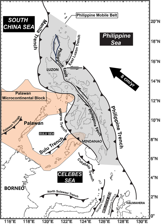
The Techtonic map of Philippines. English: Source of data comes from, and map is modified from David et al., 1997; Hall, 1987; Aurelio, 2000. |
| Date | |
| Source |
Modified from: (1) Shear partitioning in the Philippines: Constraints from Philippine Fault and global positioning system data - Scientific Figure on ResearchGate. Available from: https://www.researchgate.net/figure/Major-tectonic-elements-of-the-Philippine-region-MT-Manila-Trench-LT-East-Luzon_fig6_229713486 [accessed 12 Oct, 2019] (2) David, S (1997-08-10). "Geology and tectonic history of Southeastern Luzon, Philippines". Journal of Asian Earth Sciences. 15 (4–5): 435–452. doi:10.1016/s1367-9120(97)00027-8. ISSN 1367-9120. (3) Hall, Robert (1987). "Plate boundary evolution in the Halmahera region, Indonesia". Tectonophysics. 144 (4): 337–352. doi:10.1016/0040-1951(87)90301-5. ISSN 0040-1951. |
| Author | LkwkarenHKU |
Licensing
I, the copyright holder of this work, hereby publish it under the following license:
This file is licensed under the Creative Commons Attribution-Share Alike 4.0 International license.
- You are free:
- to share – to copy, distribute and transmit the work
- to remix – to adapt the work
- Under the following conditions:
- attribution – You must give appropriate credit, provide a link to the license, and indicate if changes were made. You may do so in any reasonable manner, but not in any way that suggests the licensor endorses you or your use.
- share alike – If you remix, transform, or build upon the material, you must distribute your contributions under the same or compatible license as the original.
File history
Click on a date/time to view the file as it appeared at that time.
| Date/Time | Thumbnail | Dimensions | User | Comment | |
|---|---|---|---|---|---|
| current | 21:12, 22 November 2019 | | 2,063 × 2,865 (356 KB) | wikimediacommons>LkwkarenHKU | Inclusion of Philippine Mobile Belt, Palawan Microcontinental Block |
File usage
The following page uses this file: