File:Rio Xingú, no Mato Grosso.jpg

Size of this preview: 800 × 451 pixels. Other resolutions: 320 × 180 pixels | 640 × 361 pixels | 1,024 × 577 pixels | 1,280 × 722 pixels | 2,710 × 1,528 pixels.
Original file (2,710 × 1,528 pixels, file size: 2.97 MB, MIME type: image/jpeg)
Summary
| Description |
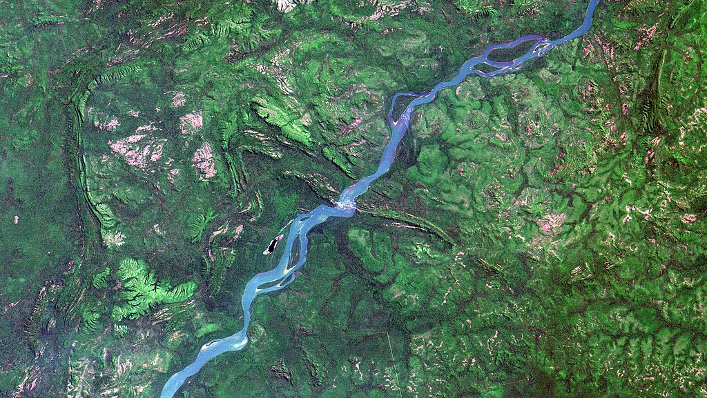
English: Corredeira da Agropexin, onde o Rio Xingú cruza a Serra da Cachoeira, logo abaixo da Ilha do Crumara, na Terra Indígena Capoto/Jarina, divisa dos Municípios de Peixoto de Azevedo, à esq. do rio, e Santa Cruz do Xingú, à dir, onde fica o Parque Estadual do Xingú. Área de contato do bioma cerrado (em verde claro), com floresta ombrófila (em verde escuro). Afloramentos rochosos em rosa / Agropexin Rapids, where Xingu River crosses Cachoeira Range, just below Crumara Island, in Capoto/Jarina Indigenous Land, at Peixoto de Azevedo, on river left, and Santa Cruz do Xingu, right, where Xingu Mato Grosso State Reserve lies, counties border. Savanna, light green, and rain forest, dark green biomes contact area. Rock outcrops in pink.
+info 1) Carta do IBGE 1:100.000 Igarapé do Travessão SC-22-V-C-VI 2) Perícia antropológica em 1997 da Justiça Federal, 3ª Vara do Estado de Mato Grosso, no processo nº 96.365-3 que cita a Fazenda Agropexin e os Kayapós na área Capoto/Jarina (busque no txt "Agropexin")
Imagem / Image CBERS4 MUX Rio Xingú, no Mato Grosso Coordenadas do centro da imagem / Image center: 9°54'13.7"S 52°49'22.2"W Data / Date: 25-08-2018 / 2018-25-08 RGB 765 (cor verdadeira / true color) Cena / Scene: 164 / 111 Autor / Author: Oton Barros (DSR/OBT/INPE) Imagem em HD / HD Image Visite-nos / Visit us: www.dsr.inpe.br |
| Date | |
| Source | https://www.flickr.com/photos/153282474@N02/45438759534/ |
| Author | Coordenação-Geral de Observação da Terra/INPE |
Licensing
This file is licensed under the Creative Commons Attribution-Share Alike 2.0 Generic license.
- You are free:
- to share – to copy, distribute and transmit the work
- to remix – to adapt the work
- Under the following conditions:
- attribution – You must give appropriate credit, provide a link to the license, and indicate if changes were made. You may do so in any reasonable manner, but not in any way that suggests the licensor endorses you or your use.
- share alike – If you remix, transform, or build upon the material, you must distribute your contributions under the same or compatible license as the original.
| This image was originally posted to Flickr by Coordenação-Geral de Observação da Terra/INPE at https://flickr.com/photos/153282474@N02/45438759534. It was reviewed on 9 April 2020 by FlickreviewR 2 and was confirmed to be licensed under the terms of the cc-by-sa-2.0. |
File history
Click on a date/time to view the file as it appeared at that time.
| Date/Time | Thumbnail | Dimensions | User | Comment | |
|---|---|---|---|---|---|
| current | 10:14, 9 April 2020 | | 2,710 × 1,528 (2.97 MB) | wikimediacommons>Jo-Jo Eumerus | Uploaded a work by Coordenação-Geral de Observação da Terra/INPE from https://www.flickr.com/photos/153282474@N02/45438759534/ with UploadWizard |
File usage
The following page uses this file: