File:Oahu, Hawai'i - NASA Earth Observatory.jpg
Oahu,_Hawai'i_-_NASA_Earth_Observatory.jpg (720 × 480 pixels, file size: 132 KB, MIME type: image/jpeg)
Summary
| Description |
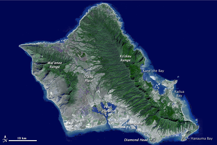
To download the full high res or the video go to: earthobservatory.nasa.gov/IOTD/view.php?id=76244&src=... Need a vacation? Paradise is as close as a mouse click away, thanks to a new fly-around tour of the island of Oahu, Hawaii. The trip comes courtesy of the Advanced Spaceborne Thermal Emission and Reflection Radiometer (ASTER) instrument on NASA’s Terra spacecraft. Sometimes called “The Gathering Place,” Oahu is the third largest of the Hawaiian Islands and home to the state’s capital city, Honolulu. The island has nearly a million residents—about 75 percent of the state’s population.Erosion and volcanism give the island its unique shape. Oahu was created from two separate shield volcanoes—Wai’anae and Ko’olau—that are connected by a central valley, the O’ahu Plain. Your virtual tour begins over Honolulu, then moves northwest over the O'ahu Plain, looking towards the northeast and the Ko’olau mountains. The valley was once largely agricultural, producing pineapple and sugar cane. Reaching the north shore, site of world-famous surfing locations like the Bonzai Pipeline, we turn to the southeast and view the Windward and East Sides of Oahu. Here you’ll find Kane’ohe and Kailua Bays and numerous small offshore islands. Reaching the southeast tip of Oahu, we fly over Hanauma Bay, a protected snorkeling and diving location, and continue past Diamond Head crater, Waikiki Beach and Honolulu. The trip ends with a flyover of Pearl Harbor, home to the largest U.S. Navy fleet in the Pacific. This flyover was created by draping ASTER image data—acquired January 13, 2010—over the new ASTER Version 2 digital elevation data. ASTER carries two telescopes used to record light reflected by the Earth. The telescopes, says ASTER science team leader Mike Abrams, are like two human eyes—seeing the world from two different angles, but combining for a three-dimensional view. Scientists used the differences between the two records to determine the ground elevation. Image courtesy NASA/GSFC/METI/ERSDAC/JAROS, and U.S./Japan ASTER Science Team. Caption adapted from the NASA Photojournal. The Earth Observatory's mission is to share with the public the images, stories, and discoveries about climate and the environment that emerge from NASA research, including its satellite missions, in-the-field research, and climate models. Like us on Facebook Follow us on Twitter |
| Date | |
| Source | Oahu, Hawai'i |
| Author | NASA's Earth Observatory |
| Camera location | | View this and other nearby images on: OpenStreetMap |
|---|
Licensing
- You are free:
- to share – to copy, distribute and transmit the work
- to remix – to adapt the work
- Under the following conditions:
- attribution – You must give appropriate credit, provide a link to the license, and indicate if changes were made. You may do so in any reasonable manner, but not in any way that suggests the licensor endorses you or your use.
| This image was originally posted to Flickr by NASA Earth Observatory at https://www.flickr.com/photos/68824346@N02/6294469627. It was reviewed on 2 July 2012 by FlickreviewR and was confirmed to be licensed under the terms of the cc-by-2.0. |
File history
Click on a date/time to view the file as it appeared at that time.
| Date/Time | Thumbnail | Dimensions | User | Comment | |
|---|---|---|---|---|---|
| current | 17:21, 2 July 2012 | | 720 × 480 (132 KB) | wikimediacommons>Dzlinker | == {{int:filedesc}} == {{Information |Description=To download the full high res or the video go to: [http://earthobservatory.nasa.gov/IOTD/view.php?id=76244&src=flickr earthobservatory.nasa.gov/IOTD/view.php?id=76244&src=...] Need a vacation? Paradise... |
File usage
The following page uses this file: