Jump to content

File:Geological map Britain William Smith 1815.jpg

From UBC Wiki

Original file (1,200 × 1,769 pixels, file size: 456 KB, MIME type: image/jpeg)

This file is from Wikimedia Commons and may be used by other projects. The description on its file description page there is shown below.

Description

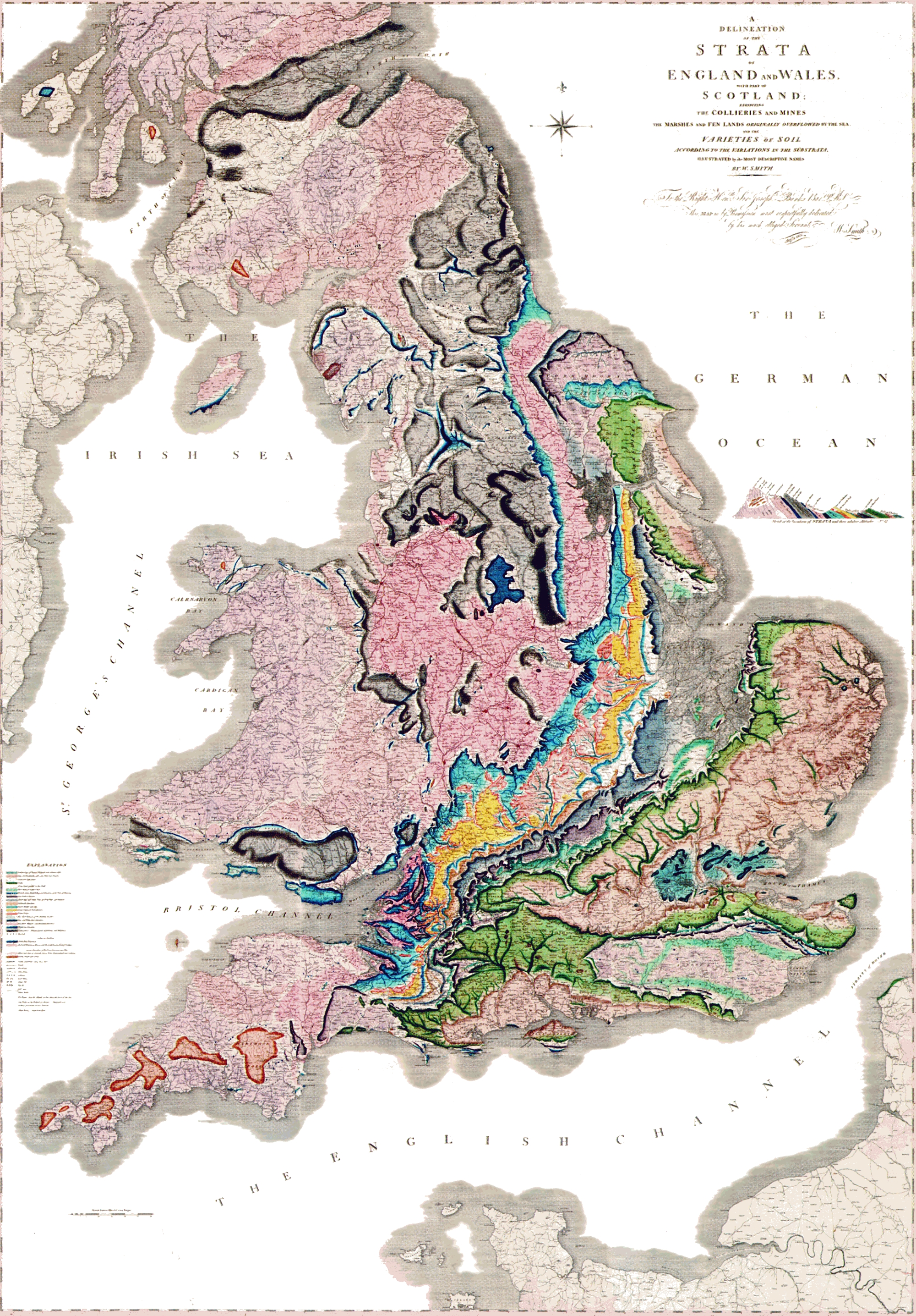
A delineation of the strata of England and Wales with part of Scotland.

(The first geological map of Britain, published by William Smith in 1815)
Date
Source

Unknown sourceUnknown source

العربية: خريطةُ وليام سميث الجيولوجية لإنجلترا وويلز وجنوب اسكتلندا، والتي تم الانتهاء منها في عام 1815م، وتُعتبر ثاني خريطة جيولوجيّة على النطاق الوطني، وكانت أدقَّ خريطةٍ في وقتها
Author William Smith (1769-1839)
Permission
(Reusing this file)
This file is in the public domain because it is a mere mechanical scan or photocopy of a public domain original, or – from the available evidence – is so similar to such a scan or photocopy that no copyright protection can be expected to arise. The original itself is in the public domain for the following reason:
Public domain

The author died in 1839, so this work is in the public domain in its country of origin and other countries and areas where the copyright term is the author's life plus 100 years or fewer.


This work is in the public domain in the United States because it was published (or registered with the U.S. Copyright Office) before January 1, 1931.

This file has been identified as being free of known restrictions under copyright law, including all related and neighboring rights.

This tag is designed for use where there may be a need to assert that any enhancements (eg brightness, contrast, colour-matching, sharpening) are in themselves insufficiently creative to generate a new copyright. It can be used where it is unknown whether any enhancements have been made, as well as when the enhancements are clear but insufficient. For known raw unenhanced scans you can use an appropriate {{PD-old}} tag instead. For usage, see Commons:When to use the PD-scan tag.


Note: This tag applies to scans and photocopies only. For photographs of public domain originals taken from afar, {{PD-Art}} may be applicable. See Commons:When to use the PD-Art tag.

Captions

Add a one-line explanation of what this file represents

Items portrayed in this file

depicts

image/jpeg

466,710 byte

1,769 pixel

1,200 pixel

c65a21e20c621c6104dce294cd0a84606dc2d7a2

File history

Click on a date/time to view the file as it appeared at that time.

Date/TimeThumbnailDimensionsUserComment
current21:03, 29 May 2024Thumbnail for version as of 21:03, 29 May 20241,200 × 1,769 (456 KB)wikimediacommons>AnticlineReverted to version as of 00:45, 11 December 2008 (UTC) as this image more accurately reflects the colouring and appearance of the map