File:Free Trade Areas.PNG

Size of this preview: 800 × 352 pixels. Other resolutions: 320 × 141 pixels | 640 × 281 pixels | 1,428 × 628 pixels.
Original file (1,428 × 628 pixels, file size: 67 KB, MIME type: image/png)
Summary
| Description |
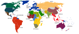
English: Free trade areas are a difficult subject. It is impossible to map all the existing free trade agreements on one map, and still make it readable. Here are presented FTAs with three or more participants. |
||
| Date | |||
| Source | Primarily based on the WTO list with exceptions for AFTZ, ASEAN+3 and AANZFTA. | ||
| Author | Emilfaro | ||
| Permission (Reusing this file) |
|
||
| Other versions |
 |
File history
Click on a date/time to view the file as it appeared at that time.
| Date/Time | Thumbnail | Dimensions | User | Comment | |
|---|---|---|---|---|---|
| current | 18:40, 10 July 2020 | | 1,428 × 628 (67 KB) | wikimediacommons>Maphobbyist | The UK left the EU and the customs union as well. |
File usage
The following page uses this file: