Course:GEOG350/Archive/Neighbourhood Project
Geography 350 Urban Landscape Project
The project is a major product of this course. I have aimed to create a project that hopefully will be an exciting and unique learning opportunity. The project will allow you to utilize and draw on the material you study in this course from the course notes and textbook. Specifically, the intent of the project is threefold: First, the project provides you with the opportunity to explore an urban neighbourhood of your choice, or geographically identifiable community, by investigating a specific issue facing the neighbourhood. Second, the project encourages you to take advantage of all the creative possibilities that Internet technology offers to analyze and display information. Third, working in small groups in an on–line forum provides an exciting opportunity to learn about the possibilities and challenges of working with other people using communication and information technology. To add 'real' world relevance to the course, we will also consider avenues for submitting your final projects to policy-makers or politicians in the city where your neighbourhood is located as a way to help connect academic research and policy.
The project is based on the pedagogical notion of "problem–based learning". This means that students will learn through the process of identifying problems and working in groups to solve them. This requires that students take initiative and become active participants. The project requires you to choose a suitable neighbourhood for analysis, seek out resources, perform analysis—and grapple with analytic and technical challenges during the process—and draw recommendations from your findings for urban policy.
It is up to you to:
- Identify an urban issue in a specific neighbourhood;
- Analyze the neighbourhood’s features and the issue it faces;
- Relate the issues you have identify to the broader factors and theories of urban change that you are learning about in the course (textbook and on–line course material);
- And finally, recommend policies as to how we might best deal with the specific neighbourhood issue you have identified.
Your project will culminate in a wiki entry hosted on the UBC wiki and must draw on academic sources to interpret your findings and produce an overall argument. During the course of the project, I will be your guide; pointing you toward useful resources and helping you answer questions that come up along the way. You will be randomly assigned into groups of four or five. I suggest you use the Connect system (Live classroom, discussion forums) as well as e–mail to communicate with your group members. Each group will have a dedicated workspace within Connect in which to plan your project. Note that only 20% of the course grade is truly derived from group work; participation in the group and the peer-review are graded individually.
As a group, you will choose a neighbourhood and complete the project requirements as described below.
Read through the project in detail!
Project Introduction
"Urban social scientists have treated ‘neighbourhood’ in much the same way as courts of law have treated pornography: as a term that is hard to define precisely, but everyone knows it when they see it." (Galster, 2001, p.2111).
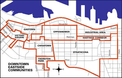
Every once in a while, I hear people tell visitors to Vancouver where to find the Downtown Eastside (DTES): "It's the few blocks surrounding Main and Hastings", is a common answer. They look puzzled when I tell them that according to the City of Vancouver, the DTES actually encompasses a number of neighbourhoods, such as Chinatown, Gastown, Oppenheimer, Strathcone, Thorton Park and Victory Square.
There is, of course, no absolute answer to the question of "what is a neighbourhood". The concept of a neighbourhood is a socially constructed one. But more importantly, I would argue, is to consider how a neighbourhood is socially constructed and what the implications are. Clearly, it is the high concentration of homelessness, drug use and prostitution in the area near Main and Hastings street that has lead many people to impose a geographic definition upon this are based on the acute social problems.
Thus, for many observers the DTES is delineated by the high concentration of visible poverty and drug use; and this deliniation results in a negative stigma that further marginalizes the people living there. Due to the low-income status of residents and years of disinvestment by governments and private landlords, the housing stock in the DTES also provides clues as to how we may define an area as a neighbourhood in our minds. When one walks from the DTES to nearby Yaletown (one of the more wealthy neighbourhoods in the city) the housing stock visibly changes from modest, at times dilapidated, medium height, rental housing to flashy, high-rise condominium towers.
The key point in the context of our class project is that cities consist of distinct neighbourhoods that are visibly distinguishable. Neighbourhoods differ by various characteristics, such as the age of housing, the type and physical condition of homes, the ethnicity, income, age and household composition of residents, presence or absence of transit systems, highways, businesses, cultural amenities among many other factors. As such, each neighbourhood likely has very different issues to deal with.
In this project, you are asked to choose one neighbourhood and analyze one specific issue facing it. There is a long history of neighbourhood level research in urban geography, and more recently urban planning as well. Of course, as with any research method there are drawbacks. Some have argued that studying cities at the neighbourhood level comes with the risk of getting lost in every detail of social life; in other words, we can't see the forest for the trees. Others believe that the explanations of urban issues and change are to be found at a larger scale, arguing that it is, for example, shifts in government policy or changes in the national and global economy that explain urban phenomena.
We ought to also consider the dangers of generalizing findings from one neighbourhood to other parts of the city, or even just how the act of operationalizing a specific area as a unit of analysis influences our perceptions and understanding of urban life. In a time of globalization, people are now often turning to the local level for solutions and as students of the city and society we may ask about both the pros and cons of such an approach, and whether the neighbourhood is even an appropriate scale for policy intervention.
"The neighbourhood is prominent in contemporary urban policy and research, but why should this be so? And can we be clear as to what 'the neighbourhood' is in any case?...In answer to his own question "Does neighbourhood still matter in a globalized world?", Forrest declares that it does, "but its degree of importance depends on who you are and where you are" (Forrest 2000, p.30). The complexity of the neighbourhood and its varying relevance to inhabitants are, in a way, the key to this conundrum: governments and policy-makers are neither able to control global capitalism and its effects, nor at the other end of the scale to direct or manage the fortunes of individual neighbourhoods within their jurisdiction. Neighbourhood change is proving unpredictable and resulting in ever-wider gaps in fortune and propserity between places within single regions and countries" (Kearns and Parkinson, 2001, p.2103).
Keeping the limitations in mind, policy-makers and a range of academics often highlight the unique insight that can be attained by studying specific neighbourhoods. Local activists, but also researchers, commonly point to the need to empower existing residents in an area to find solutions to pertinent problems. Many researchers and policy-makers see neighbourhood analysis as an essential component of better comprehending and producing solutions to urban issues, such as poverty, homelessness, housing affordability and even environmental sustainability. Thus, I have aimed to create a project that hopefully will be an exciting and unique learning opportunity that also has practical relevance.
The following is a list of suggested readings that provide you with background information on neighbourhood studies in urban geography and the closely related field of urban planning. It is useful to have at least some background information from the literature on how and why neighbourhoods are being studied before embarking on your own project. I recommend that you read at least one of these and skim the content of one or two more.
- Butler, T. and Robson, G. (2001). Social capital, gentrification and neighbourhood change in London: A comparison of three south London neighbourhoods. Urban Studies, 38(12), 2145-2162.
- Galster, G. (2001). On the nature of neighbourhood. Urban Studies, 38(12), 2111-2124.
- Kearns, A. and Parkinson, M. (2001). The significance of neighbourhood. Urban Studies, 38(12), 2103-2110.
- MacDonnell et al. (2004). Poverty by Postal Code: The Geography of Neighbourhood Poverty 1981-2001. Toronto, ON: United Way of Greater Toronto and The Canadian Council on Social Development.
- Silver, C. (1985). Neighbourhood planning in historical perspective. Journal of the American Planning Association, 51(2), 161-174.
There are six project components:
Project Components
1. Choose a neighbourhood
The first project component requires you to choose a neighbourhood/community as a group, set up the wiki page and provide me with a one page overview of the issue you have identified. Select an issue that is affecting and/or important to your neighbourhood. Before deciding on an issue (and neighbourhood), you may want to spend some time reviewing newspapers or other forms of media. No grade is assigned, but your group will lose 1% of your final course grade for each day late.
A penalty also applies if your proposal does not include all required components. In your one-page proposal, you need to introduce me to the issue, very briefly explain why it is worth analyzing (i.e., why is it an issue and why does it need resolution?) and finally provide me with at least two academic sources (simply list the citations as a bibliography) that deal with your issue. Your textbook is a valuable source, but here you need to include at least two other academic sources. The bibliography in your text is a helpful starting point.
For information on setting up your wiki page, go to http://wiki.ubc.ca/Course:GEOG350/2013ST1
When you are ready to submit your proposal, upload it to the Assignments drop box on Connect. You can upload only one document per group, so make sure you decide who is going to submit the work beforehand.
2. Analyze issue & neighbourhood
The second project component requires you to begin analyzing an issue and your neighbourhood. This portion of the project is worth 10% of your final course grade.
Your wiki entry needs to introduce the neighbourhood, define its boundaries, provide relevant background information on the neighbourhood (e.g., history, demography, characteristics of the built form, transportation infrastructure), introduce the issue and explain in detail why it is worth analyzing (i.e., why is it an issue, why should we analyze it, why does it need resolution, who is affected, why and how etc.). At this stage you also need to have a preliminary explanation of the factors that are causing the issue you have identified to come about (i.e., what are the underlying causes of this issue? Explain why). In preparing the assignment, you are encouraged to draw upon a range of sources. However, in making sense of and presenting the issue (and its underlying causes) you must draw on academic sources! This can include material from the course text or sources cited therein, but you must also find academic sources other than the text.
When your wiki entry is ready, update the course wiki page, located at http://wiki.ubc.ca/Course:GEOG350/2013ST1
Late penalties apply at 1% of your final course grade per school day.
3. Make Site Public
If you have not alredy updated the course page, all groups must make their draft project sites public for all classmates to view (so that everyone has plenty of time to conduct their peer-reviews). I will deduct 1% of your final course grade for each day that your project site is not made public for others to view. The wiki entry should include at least a draft overview of all the major parts by this date and the bulk of the writing should be nearing completion. You should have also addressed my comments from the draft stage at this point. Proof read your writing.
4. Peer Review
Every student is required to provide peer–review for two other groups (I will randomly assign these), See the project web page for further information on how to conduct this assignment. This assignment is conducted individually.
To see the URL of the groups you have been assigned, go to http://wiki.ubc.ca/Course:GEOG350/2013ST1
Submit your peer review to me via the Assignments drop box in Connect. You must also submit your comments as an attachment to the other two groups via the e–mail tool.
Your comments (peer-review) count toward 15% of your final grade and are graded individually (i.e., each student receives a grade for their own comments only).
5. Final project
The final version of your project should now be posted on the wiki. The final project is worth 15% of your final course grade. You need to send me an e–mail when your site is ready for me to grade. Late penalties apply at 1% of your final course grade per school day.
Your project needs to include a clear argument as to why your issue is important (and worth analyzing), who it affects and how. You need to clearly introduce your neighbourhood, providing sufficient background information for the reader. The background information cannot just be 'filler'; it needs to be relevant to the issue you are addressing in your project. Your project also needs to include a coherent argument about the underlying factors that are causing the issue to come about. Finally, from your analysis of the underlying factors you need to draw detailed and well-explained conclusions about possible solutions to deal with the issue (make policy recommendations). The merits of your proposed solutions need to be substantiated by the literature and a well-reasoned argument.
Remember, be creative and have fun with it!
6. Project participation
This mark will be assigned by your peers at the end of the course
At the end of the project, you will be asked to grade the other members of your group. Group participation is worth 10% of your final course grade. Late penalties apply at 1% of your final course grade per school day.
Submit your group grades to me via the Assignments drop box in Connect. I will provide you with a form toward the end of the course that explains how to grade your peers. I do not anticipate that this would take you more than about 15 minutes at the most. Everyone is required to complete this evaluation.
Choosing a neighbourhood/issue
You may choose any neighbourhood in any city as long as there are defining characteristics for your neighbourhood: This could include official municipal boundaries, name recognition by residents or the presence of distinct socio-economic or ethnic communities. The only restriction is that at least one of your group members has to currently live in the city where your case study neighbourhood is located as visiting the neighbourhood will provide you with key information needed to complete this project (i.e., photographs, description of the built form, presence of amenities etc.). You will also want to make sure that there is sufficient information available about your neighbourhood, so do some research before making a final decision.
Deciding on an urban issue that interests you first may help you in deciding what neighbourhood to study. Maybe you are particularly interested in housing affordability, environmental sustainability, poverty, gentrification, public transportation, urban entertainment venues, real estate development or any other urban issue. Doing some research on the issue first can help you identify a neighbourhood where the issue is predominant or worth investigating for other reasons. Note that you do not have to necessarily find an academic article that specifically talks about your neighbourhood (although if you do that is great). However, you will have to find information about your neighbourhood in the popular press, urban history documents etc. and you will have to find academic sources on the types of issues that are relevant to your neighbourhood.
How to Cite Sources
You must cite all sources in your project; that includes newspaper articles, books, academic journals, reports, films, photos, data, sounds and web pages etc. It does not matter to me what citation style you use, as long as your consistent throughout your project. Given the format of this project, it may be easiest to cite your sources in the text (author, year), and provide a separate page listing sources in alphabetical order. Even though I encourage you to link your project to other web sites, creating a hyperlink (or web link) to your sources alone is NOT an acceptable citation style.
Academic Integrity
Students are expected to know what constitutes plagiarism and that plagiarism is a form of academic misconduct. As such, plagiarism is subject to penalty. Please review the Plagiarism and Student Discipline sections of the UBC Calendar, available at http://help.library.ubc.ca/planning-your-research/academic-integrity-plagiarism/ .
Instructors are required to report all instances of academic misconduct to the Department, who will in turn notify the Dean’s Office. The penalty for plagiarism or for cheating is serious and normally entails suspension from the University and a notation on the student’s transcript.
Resources
- The University Calendar contains the full text of the Academic Misconduct Principles and Procedures: http://www.calendar.ubc.ca/vancouver/index.cfm?tree=3,54,111,0
- Academic Integrity Resource Centre: http://learningcommons.ubc.ca/resource-guides/avoiding-plagiarism/
- UBC Policy #85: Scholarly Integrity: http://www.universitycounsel.ubc.ca/policies/policy85.pdf
Useful Sources
You will likely find a large number of academic articles about your city or particular urban issue, but not all (or perhaps any) will necessarily be specific to your neighbourhood. While academic sources (books and articles) and government reports should form a bulk of your sources, these need not be specific to your neighbourhood as long as you can draw inference from the sources to your particular case. For instance, you may find reports and journal articles on the decline of social housing in Canadian cities but the work is not specific to your neighbourhood. This is okay as you could document the existence of social housing in your neighbourhood using photos, newspaper articles and describing their physical characteristics as a specific example of disinvestment in social housing, as long as you can still set the case of your neighbourhood in the context of the academic literature.
The following sources are meant as a useful starting point. They are by no means required readings or sources. It is up to you to decide whether these sources are useful for your particular project. I do expect you to go beyond the sources I have listed here. Note that this resource page is not formatted as a formal bibliography.
Empirical evidence:
Canadian Census data
City of Vancouver neighbourhood statistics
City of Toronto neighbourhood profiles
Maps:
UBC library map resources
Statistics Canada maps and geography
How to create your own customized Google maps
Method: How to collect, analyze and display information to make an argument*
Dandekar, H. (1988). The Planner's Use of Information. Stroudburg, PA : Hutchinson Ross Publishing Co.
Klass, G. (2008). Just Plain Data Analysis: Finding, Presenting, and Interpreting Social Science Data. New York: Rowman and Littlefield Publisher. Klass also has an informative website on presenting simple data.
Weston, A. (2009). A Rulebook for Arguments. 4th Ed. Indianapolis: Hackett Publishing.
Statistics: Power from Data! is a product from Statistics Canada that will assist readers in getting the most from statistics.
A guide to simple data use and analysis hosted by the University of Michigan.
- Also consult your textbook for examples on how to use qualitative and quantiative evidence in your writing.
Useful urban academic journals that can be found in the UBC library system:
- Urban Studies
- Environment and Planning A
- Journal of the American Planning Association
- Journal of Planning Education and Research
- Journal of Urban Affairs
- The Canadian Geographer
- Housing Studies
- Journal of Urban Design
- The Urban Geographer
- The Professional Geographer
Other interesting sources:
Calculate the 'Walkability' of your neighbourhood
Google Transit: How long does it take from your neighbourhood to major retail locations, the city centre, the train station using public transit or by walking? Collect the information from Google transit and summarize it in a spreadsheet table.
Grading
Given that this is a group project, you will necessarily have to delegate the work. I will assign one grade for the whole group, except for the peer-review component. At the end of the project, you will be asked to grade the other members of your group. I will use these feedback forms to adjust your final project grade by 10% of the total:
This means, the project is worth 50% of your final grade. 25% of this is assigned to all group members by me based on the sum of your project outputs. The group evaluations account for 10% of your project grade. Your peer-review comments, which you complete individually, are graded by me and account for 15% of your grade.
An example: If I assign your group a grade of 90% for your draft project, a student in this group receives 70% on their peer-review comments, the group receives a 82% on their final project, and his/her classmates assign this same student a 60% for their group participation; this student's project grade will be calculated as follows:
[10% * .9 + 15% * .7 + 15% * .82 + 10% * .6] / 50% = 37.8/50 * 100% = 75.6%
When grading your projects, I will be looking for synthesis and analysis. To receive an A-grade you must move beyond simple description. I will expect you to include a variety of evidence from various sources (qualitative and quantitative). Academic sources (books and journal articles) should be the main source of information to help you interpret your findings, but you will necessarily have to turn to various other sources (web, newspapers, census, government reports etc.) to describe and analyze your neighbourhood. You will be graded on your ability to collect, analyze and synthesis information. Your arguments have to be supported by evidence. A project that merely reproduces information will be considered insufficient. I do not expect you to conduct any in-depth statistical or quantitative analysis, but I will be looking for some evidence of inclusion and interpretation of numerical information. While there are no specific requirements on the inclusion of graphics, visual illustrations (such as maps, tables, photos, figures etc.) are strongly encouraged.
I will be following the Faculty of Arts guidelines in determining your grades. The guidelines offer a broad-brush characterization of the type of work that might be associated with various ranges of grades:
| Grade | Performance | Description |
| 80% to 100%(A- to A+) | Exceptional performance | Strong evidence of original thinking; good organization; capacity to analyze and synthesize; superior grasp of subject matter with sound critical evaluations; evidence of extensive knowledge base. |
| 68% to 79%(B- to B+) | Competent performance | Evidence of grasp of subject matter; some evidence of critical capacity and analytic ability; reasonable understanding of relevant issues; evidence of familiarity with the literature. |
| 50% to 67%(D to C+) | Adequate performance | Understanding of the subject matter; ability to develop solutions to simple problems in the material; acceptable but uninspired work, not seriously faulty but lacking style and vigour. |
| 00% to 49%(F) | Inadequate performance | Little or no evidence of understanding of the subject matter; weakness in critical and analytic skills; limited or irrelevant use of the literature |
KEEP A BACK-UP OF YOUR WORK ON YOUR COMPUTER AND MEMORY CARD AT ALL TIMES. TECHNICAL PROBLEMS CAN AND DO OCCUR. You are responsible to have a back-up copy of your work (in MS Word) in case there is a technical issue.