APBI402-Nepal
Case Study
Soil Erosion on Sloping Agricultural Lands in the Middle Mountains of Nepal
The Hindu Kush-Himalayas are known for their mountains (including Sagarmatha the highest peak in the world), and their diversity of flora, fauna and culture. However, these mountain ranges are also known for environmental issues, including media reports on deforestation, soil erosion and downstream flooding. It is estimated that 45% of the total land area of Nepal is affected by water erosion (Bhandari 2014), and erosion rates are estimated to be as high as 50 t/ha per year (Ghimire et al. 2013, Shrestha 1997). This topsoil loss through surface erosion and the subsequent decline in soil fertility is a concern for both sustainable agriculture and food security (Shah 2002).
There are three theories for the causes of these issues: 1) that human activity is the main cause of land degradation; 2) that natural processes outweigh the importance of human impact; and 3) that land degradation is a product of natural and social forces (Ives and Messerli 1989, ICIMOD 2000).
Overall case specific learning outcome: to characterize the soil quality of sloping agricultural lands in Nepal with an emphasis on soil physical properties. With the help of a series of guiding questions and the interaction with instructors and your group members, you will accomplish the following tasks:
- Become familiar with erosion processes
- Interpret the results of erosion plot data
- Assess the major causes of soil erosion on sloping agricultural lands in Nepal
Week One
Case study background – the Jhikhu Khola watershed
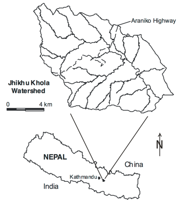
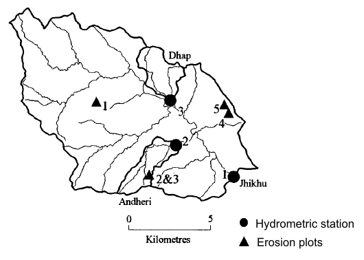
The Jhikhu Khola watershed is located 35 km east of Kathmandu in the Middle Mountains of Nepal. The watershed is 11,100 ha in area, and is connected to Kathmandu by paved road. The population in the watershed was 48,728 in 1996 and had been increasing at a rate of 2.6 % per year; which represents a doubling of the population roughly every 25 years.
Climate
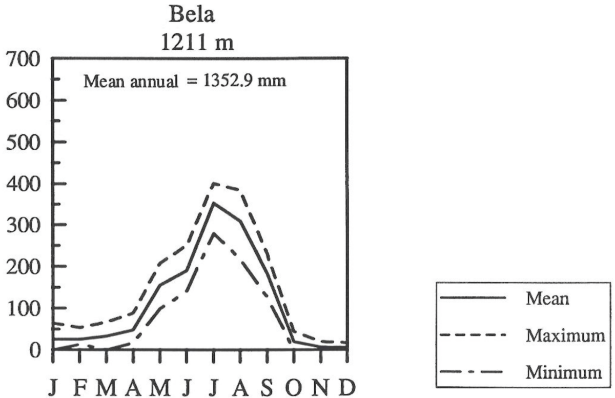
Climatic conditions are favourable for crop production on a year round basis, but the rainfall distribution is highly skewed with 70-80% of the rainfall occurring over a 4 month monsoon season. During the rest of the year, rainfall is sporadic and water shortages occur during the prolonged dry season. Annual precipitation recorded in the watershed from 1993 to 2001 ranged from 942 to 1,929 mm. Air temperatures range from 3 to 40oC in the lower watershed, and decrease by some 3oC at higher elevations.
Topography
The topography of the Himalayas is unique; over a distance of 170 km, elevation changes from 80 meters above sea level (masl) in the Indo-Gangetic plains to more than 7,000 masl. In the Jhikhu Khola watershed elevation ranges from 790 to 2,200 m. Steep side slopes result in a high erosive potential, while the flat valley bottom acts as a sediment depository.
Soils
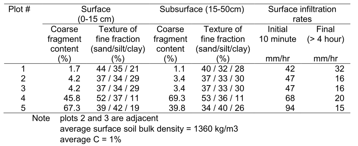
Soils in the watershed are broadly classified into red and non-red soils, with red soils comprising 37% of the watershed. The red soils are Rhodustults and Haplustults (Ultisols), formed on quartz-rich phyllites. The red soils are highly weathered, are acidic with a high Fe and Al content, have high clay content dominated by kaolinite, have low infiltrabilitiy, and are prone to erosion. The non-red soils are dominantly Rhodustalfs and Haplustalfs (Alfisols) formed on schist, quartzite, sandstone and siltstone. The non-red soils are younger, less weathered, less acidic and coarser textured than the red-soils; however the clay content is still relatively high with a mix of illite, montmorillonite and kaolinite. See details on soil texture for the erosion plots in the data section.
Land use and land cover
Land use in the watershed is categorized as follows:
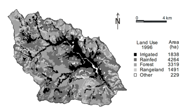
- Irrigated agriculture (khet) - level terraces with a bund along the terrace riser; irrigated by conventional flood or furrow irrigation
- Rainfed agriculture (bari) - sloping terraces; no provision for irrigation
- Forest - crown density >10%
- Rangeland - utilized dominantly for grazing, or cut and carry forage; crown closure < 10%
- Other
The cropping systems are rice dominated irrigated land and maize dominated rainfed uplands. Individual households typically own small, dispersed parcels of land totalling < 1 ha in area, 80% of which is rainfed. Rainfed, sloping agriculture increased by 510 ha from 1972 to 1990, mostly through the terracing and cultivation of former range and abandoned lands, in part in response to the growing population and increased demand for food. Up to 39% of the agricultural expansion occurred on slopes greater than 35%; raising concerns about surface runoff and erosion.
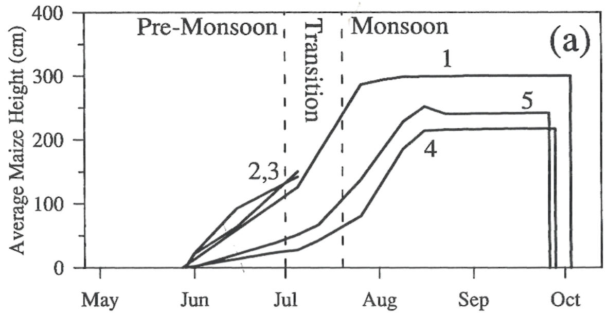
The dominant crop rotation on rainfed sloping agriculture is fallow (pre-monsoon), maize or maize inter-cropped with lentils (monsoon), and wheat or potatoes (winter).
Learning objective
Understand the factors controlling soil erosion in general, and water erosion in particular.
Student tasks
- Familiarize yourself with soil erosion process in general, and water erosion in particular.
- Develop a list of the main factors controlling water erosion, and their relative importance in the Jhikhu Khola watershed.
- Review background information on the case study.
Guiding Questions
- How do geologic and anthropogenic erosion rates compare?
- What are the main factors controlling water erosion?
- How do soil properties effect water erosion?
- When would you expect the highest erosion rates to occur in a Monsoon climate?
- How do water erosion processes (and the factors which influence them) change with scale from plot to the micro-watershed to watershed?
Key Reference
- Bhandari G. 2014. A review on soil erosion conservation measures in Nepal. Peak Journal of Physical and Environmental Science Research Vol. 2(3): 41-47.
- Lauterburg A. 1993. The Himalayan highland-lowland interactive system: do land use changes in the mountains affect the plains? In Messerli B. Hofer T. Wymann S (eds). Himalayan environment pressure: – problems – processes. Geographica Bernensia G38. pp 21-30.
- Pennock D. 2019. Soil Erosion: the greatest challenge for sustainable soil management. FAO, Rome. 100 pp.
Week Two
Background
A range of methods have been used to study soil erosion by water including erosion plots, erosion pins, tracers and stream sediment monitoring – each focusing on specific processes and spatial / temporal scales. Erosion plots can be efficiently used to diagnose patterns of sediment production over small spatial scales (<1 ha). Erosion plots in the field usually consist of small plots delineated with plastic or metal sheets, a collection tank(s) on the bottom of the plot with the volume of sediment and water determined after every storm event.
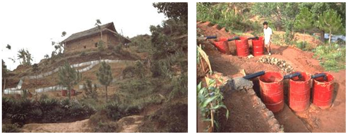
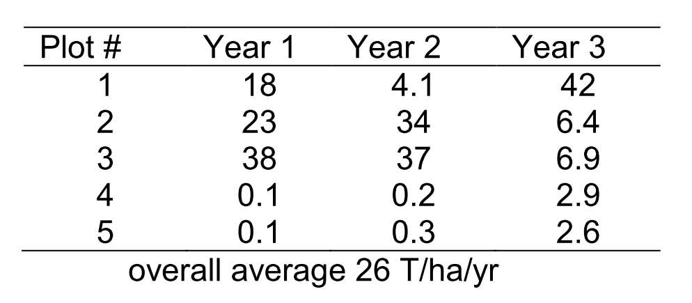
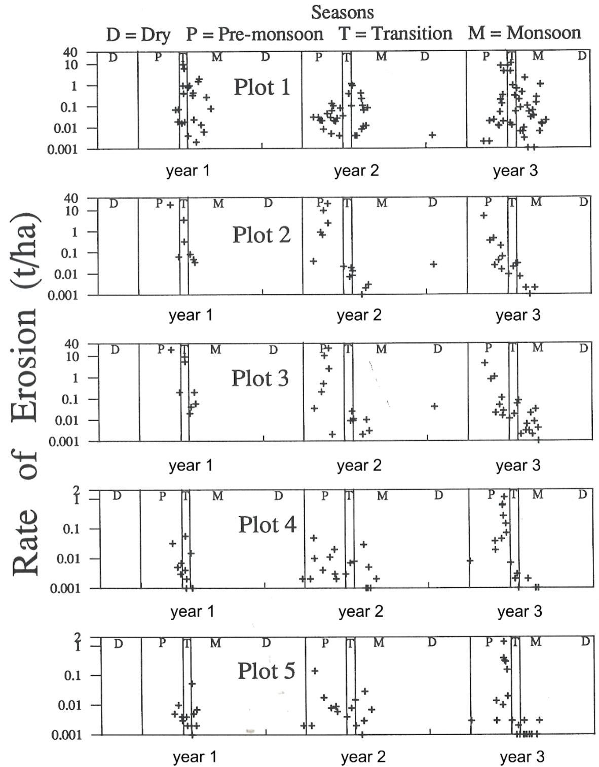
In the case of the Jhikhu Khola watershed, 5 plots were established, each contained two terraces connected by a step terrace riser. The cropping practice on all plots was the same: maize during the rainy season, and either millet or wheat during the dry season. All plots were on non-red soils (Table 1). Erosion and runoff were measured on an event basis. Three drums were located in series at the outlet of each plot (Photo 1). After each erosion causing storm event, the total height of water and sediment in each drum was measured, and water and sediment samples were taken. Using these measurements, and the known dimensions of the drums, total erosion and runoff were calculated for each storm event. An automated rain gauge was installed to monitor rainfall amount and intensity.
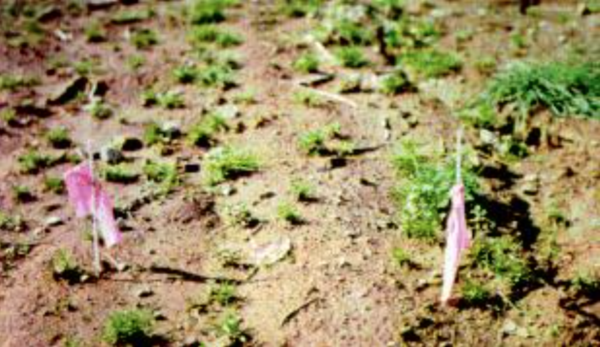
In addition to monitoring erosion on upland plots, sediment accumulation on lowland rice fields was determined using accumulation pins which indicate a change in soil level at specific locations. Between 4 and 12 pins were installed in each individual field, and the soil height relative to a notch showing the original soil level was measured before the pre- monsoon and after the monsoon season.
Learning Objective
Assess erosion plot data and investigate potential factors contributing to spatial and temporal variability in soil loss.
Student Tasks
- Review the rainfall, erosion plot and accumulation pin data from the Jhikhu Khola watershed.
- Investigate potential relationships between soil loss and the factors controlling water erosion.
- Gain basic understanding of soil quality concept.
Guiding Questions
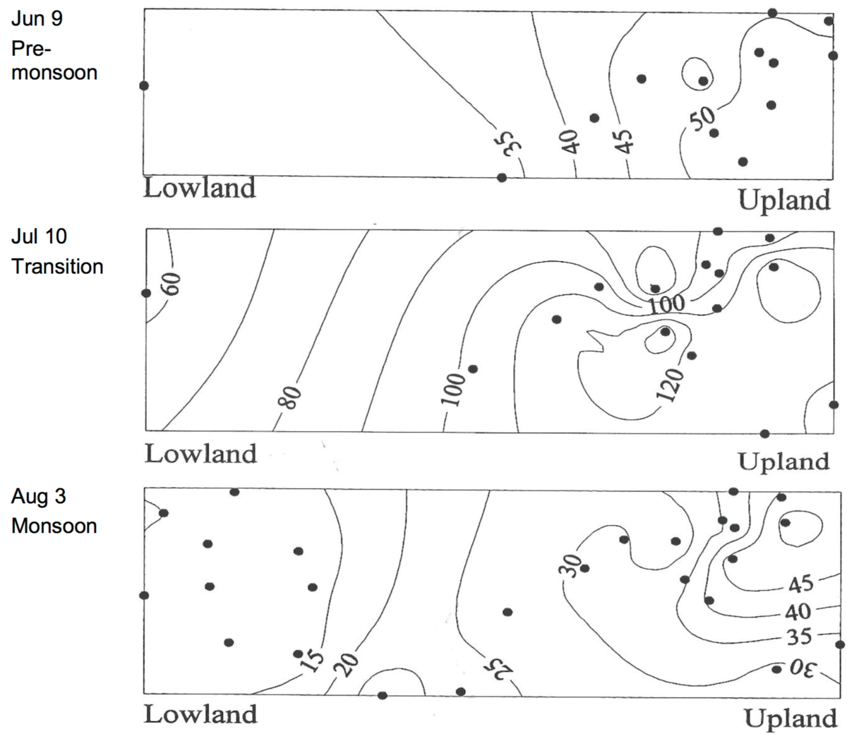
- How does rainfall vary spatially and temporally in the watershed?
- How does the erosion data vary over time for each of the plots?
- How does erosion vary between plots?
- How well does rainfall intensity relate to soil loss for each of the plots?
- Do soil characteristics relate to soil loss for each of the plots?
- Are other factors potentially important in determining soil loss, and what might they be? Hint consider the universal soil loss equation.
- What happens to sediments eroded from upland agricultural fields?
Key Reference
Appendix II. Notes and definitions
Week Three
Learning Objective
Assess the impact of climate, soil physical characteristics and land management practices on soil loss
Student Tasks
- Explain the erosion plot results determined in week 2, and their implications for agricultural soil management on sloping lands.
- Develop a soil quality framework for soil erosion.
- Prepare group presentation.
Guiding Questions
- Given your knowledge of the factors influencing soil erosion by water, what might explain the spatial and temporal changes in soil loss (or lack of change) in the data provided?
- Do the highest erosion rates occur during the time period that you anticipated? And if not, why?
- What are the implications of your results for soil management on sloping agricultural land?
Week Four
Tutorial: Group presentations and synthesis
Each group will present results of their work on case 1 (please remember that your presentation should be max 20 minutes long) and along with the instructors compare and contrast the methods of diagnosis and interpretations of soil physical quality in the case studies:
- Forest landings
- Soil erosion in Nepal
- Rangelands in southern BC
The presentations will be evaluated on the basis of content, structure, and delivery.
One of the signs of successful presentation is how well the presentation engages other groups into discussion.
Appendix I. Data





Appendix II. Notes and definitions
Khet: irrigated agriculture
Bari: rainfed agriculture
| Seasons: | Pre-monsoon | May 1 to Jun 30 |
| Transition | Jul 1 to 19 | |
| Monsoon | Jul 20 to Sep 30 | |
| Dry (winter) | Oct 1 to Apr 30 |
Note: In some contexts, the transition season may be included within monsoon
Cropping system:
Upland rainfed Bari: maize or maize intercropped with beans (early May to early Sept) followed by wheat or potatoes in the dry season (fallow pre-monsoon common)
Irrigated Khet: monsoon rice, followed by potato in the winter and early maize or tomato in pre- monsoon. Note monsoon rice is flood irrigated (channelized diversion to terraced fields)
Nepal study site soils (USDA Soil Taxonomy):
| Non-red soils: | Order: Alfisol (Luvisol in FAO classification) | |
| Suborder: Ustalfs | ||
| Great group: | Rhodustalf | |
| Haplustalf | ||
| Red soils: | Order: Ultisols | |
| Suborder: Usults | ||
| Great group: | Haplustult | |
| Rhodustults | ||
References
Chalise S.R. 2001. An introduction to climate, hydrology and landslide hazards in the Hindu Kush-Himalayan region. In Upreti B.N. Tianchi B.N. Chalise S.R. (eds) Landslide hazard mitigation in the Hindu Kush-Himalayas. ICIMOD, Kathmandu. 329 pp.
Ghimire S.K. Higaki D. Bhatttarai T.P. 2013. Estimation of soil erosion rates and eroded sediment in a degraded catchment of the Siwalik Hills, Nepal. Land 2: 370-391 DOI:10.3390/land2030370
ICIMOD (International Centre for Integrated Mountain Development). 2000. Land policies, land management and land degradation in the Hindu Kush-Himalayas: Nepal study report. MFS Case Study Series No. 00/2, ICIMOD. 105 pp. http://lib.icimod.org/record/24045/files/Land%20policies%282000%29.pdf
Ives J.D. Messerli B. 1989. The Himalayan dilemma – reconciling development and conservation. London, Routledge. 295 pp.
Oldeman L.R. Hakkeling R.T.A. Sombroek W.G. 1991. World map of the status of human- induced soil degradation: an explanatory note. ISRIC, UNEP. 41 pp.
Shah R.P. 2002. Improving food security and livelihood of mountain people through development of agriculture. Proceedings of International Conference on Mountains, Kathmandu Nepal March 6-8, 2002. http://www.mtnforum.org/sites/default/files/publication/files/360.pdf
Shrestha D.P. 1997. Assessment of soil erosion in the Nepalese Himalaya, a case study in Likhu Khola valley, Middle Mountain region. Land Husbandry 2(1): 59-80.