Library:HSS GIS Services
GIS at a Glance
GIS Data
- To find commonly-requested free datasets online, visit UBC's Geomatics website and its Data Sources portals.
- The library's GIS Data web page has information about finding, using, and citing geospatial data.
- We also have GIS data on a library server called Abacus. Datasets include census tables and geography, base map data, and transportation network data, among others. Instructions on finding data within Abacus can be found on the library's GIS Data web page.
GIS Software
- ArcGIS, FME and SPSS software are available in Koerner Library, Room 217.
- GIS and statistical software are also available in the Data/GIS Lab. For more access information, click here.
- For more information and options, click on the GIS Software tab above.
GIS Help
- The library can help you learn GIS software, concepts, and methodologies. Click on the Learn GIS tab above to see the various methods available.
- You can also speak to library staff for more help and information. Click on the Get Help tab above for library staff contact information.
What is GIS?
Geographic Information Systems
Geographic Information Systems, or GIS, are computer software programs that capture, store, analyse, query, and display geospatial data. (GIS can also stand for Geographic Information Science, but in this document we are referring to the computer software and data, rather than the academic study of GIS.)
GIS (or Geospatial) Data
GIS data sets can be geometric:
- Points represent locations (like fire stations, schools or cities)
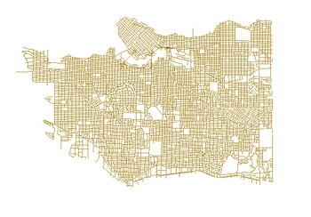
- Lines represent networks (like roads, railroad tracks, power lines, trails)
- Polygons represent areas (like parks, city boundaries, building outlines, census tracts)
(Think of how these things are represented on paper maps.)
These data sets are called vector data sets, or shapefiles (or feature classes within a geodatabase).
Each data set has only one type of geometry, but may have many features.
- A road data set will only have lines (no points or polygons), but may have thousands of lines representing all of the roads in a given area.
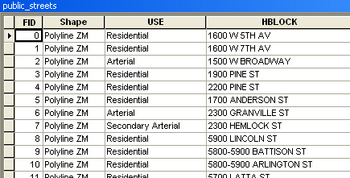
Each feature within a data set has information, or attributes, associated with it.
- Each road segment may include the road's name, highway number, number of lanes, speed limit, or address range, for example.
Data sets can also be rasters:
Rasters are like digital images. They are made up of square cells (pixels) in a grid, similar to a digital photograph.
- Cell values are numbers that represent the dominant characteristic within a cell (like elevation, vegetation type, or temperature).
- A cell value in an elevation raster may equal 1705, meaning that the average elevation within that 30-meter-by-30-meter cell is 1,705 meters above sea level. Colours can then be used to display the cell's number values.
Bringing Data Together
With GIS software, users can overlay multiple data sets for the same geographic area, and examine the spatial relationships between them. These relationships include:
- Size (length, area)
- Distance (between or within features)
- Intersection (where features meet)
- Containment (what features are within another feature, such as what trees (points) are within a park (polygon))
- Adjacency (what features are next to each other, such as what province is next to another)
In order to do this, the software must know the actual locations of the features. In simplified terms, data sets represent the best approximate locations of features on Earth.
The Power of GIS
GIS software is very powerful, and can be used to manipulate GIS data in many ways: geometric features can be moved or reshaped; attributes can be changed; features can be added or deleted. Data sets are DYNAMIC. And hundreds of tools are available to analyse and evaluate the spatial relationships between data sets. We can begin to see new patterns and characteristics of the world around us by viewing the spatial relationships between the earth's features.
The technology is constantly improving and expanding the ways in which we examine the world around us.
For More Information...
More detailed explanations of GIS are available on the following websites:
http://www.esri.com/what-is-gis
http://www.youtube.com/watch?v=oMUGp0rGf7I [YouTube video by Esri]
http://downloads2.esri.com/ESRIpress/images/108/UNDERSTAND_intro1.pdf
Learn GIS
ArcGIS Tutorials
To learn more about how to use Esri's ArcGIS software suite, online self-guided tutorials are available through the Esri Virtual Campus. Courses are free for UBC students, faculty and staff.
To get access, please contact Paul Lesack (paul.lesack@ubc.ca), and provide him with the course name. Only web courses authored by Esri (top left in the catalog description) are available to us for free.
Esri Conference Technical Session Videos
Each year at the ESRI International Conference, the in-depth technical sessions are recorded and made available afterwards. You can download them directly from the Geomatics website using your UBC computer (or by using VPN from off-campus).
GIS Courses
For a listing of GIS and GIS-related courses offered at UBC as well as other colleges and universities, please visit UBC's Geomatics website course page.
Data/GIS Library Handouts
Below are a list of helpful library handouts:
1. Getting Started with Searching Abacus for Geospatial Data
2. Getting Started with the BC Economic Atlas
3. Getting Started with GeoSearch
Note: Normally CSDs = cities
GIS Data
- The library's GIS Data web page has information about finding, using, and citing geospatial data.
- To find commonly-requested free datasets online, visit UBC's Geomatics website and its Data Sources portals:
- GIS Data held by the UBC Library can be found in Abacus.
GIS Software
Koerner Library, Room 217
Room 217 provides access to PC workstations with a wide range of software, including productivity, GIS, and statistical software. The room is accessible on a first-come, first-served basis any time that Koerner Library is open and there isn't a class being held in the room.
Please note that when you log out of the lab's computers, all files stored on the computer will be deleted. Please store all files on an external storage device.
Location: Second Floor of Koerner Library, near the map cabinets.
Hours To check room availability, please check the calendar posted on the wall outside the room, or see the online calendar of events.
Data/GIS Lab
ArcGIS Suite and statistical software (including SPSS, R, and Stata) are available in the Data/GIS Lab in Koerner Library, Room 218A (second floor). The lab is available Monday through Friday from 10:00am to 5:00pm on a first-come-first-served basis for those needing access to GIS and statistical software. Inquire at the Research Commons desk to be let in to the lab. Keys are no longer available for the room, and applications are no longer required.
Please note: During certain hours, the lab is used for Research Commons consulting. During these times, there will be fewer computers available, and there will be conversations in the room. For Research Commons hours, please see the Consultations tab on the Research Commons homepage.
ArcGIS Student Edition
Esri ArcGIS Student Edition software (1-year licence) is available to UBC students, faculty and staff through the Faculty of Forestry for $25. The software includes Spatial, Geostatistical, Network, and 3D Analyst extensions. A Registration Code can be purchased from the Faculty of Forestry receptionist in room 2045, Forest Sciences Centre with $25.00 and presentation of your UBC card.
For a complete list of Esri software and licences available at UBC, please visit UBC's Geomatics website.
Open Source GIS Software
There are free, open source GIS software packages downloadable from the web. Several can be installed on Mac OS (whereas the Esri ArcGIS Suite cannot). The most common of these is QGIS. A full list of open source GIS software and tools can be found at http://opensourcegis.org/
QGIS
For more information on QGIS, including download instructions and users guide, visit http://www.qgis.org/
A QGIS training manual can be found at http://manual.linfiniti.com/en/foreword/index.html
GIS at UBC
UBC Geomatics Website
A wide range of information pertaining to UBC campus GIS can be found on the Geomatics website, including software, courses and data.
UBC GIS Users Group
UBC students, faculty and staff gather once a month to discuss various uses of GIS on campus. Meetings are usually held September through April (except December) on the last Wednesday of the month at 3:00 PM in Koerner Library Room 216 (second floor - one level down from the entrance).
For information on the next presentation, visit the Geomatics website UBC GIS Users Group page.
UBC GIS Listserv
The UBC campus-wide GIS Listserv provides information on meetings, new data and other relevant GIS news. It is also a forum for GIS users on campus to share ideas and ask questions. To join, contact Jerry Maedel at 'jerry dot maedel at ubc dot ca' and provide him with your email address.
Get Help
The UBC Library provides access to GIS resources, including data, hardware, software and tutorials.
We can assist you with:
- locating and acquiring geospatial data
- incorporating data into research projects, including format conversion
- learning GIS software and analysis techniques
We also provide technical support for Data/GIS Lab users.
Contact Us:
- Paul Lesack, Data/GIS Analyst
- Koerner Library 218C
- paul.lesack@ubc.ca
- 604.822.5587
- Kelly Schultz, Data & GIS Librarian
- Koerner Library 219G
- kelly.schultz@ubc.ca
- 604.822.8667


