Course:GEOG350/Archive/2010WT2/UBC Point Grey
This is the page for Group 3's project. Group members: Yi Ting Lin, Dustin Louis, Jennifer Talbert, Kelly Aspinall, Mike Bandy
Introduction
Group 3 will be examining the neighborhood of UBC Point Grey Campus. This neighborhood - located at the western end of the "Broadway Corridor" - is home to a largely residential population. The UBC campus and surrounding University Endowment Lands are both quieter and pricier areas of Vancouver, and are rather isolated relative to the rest of the city.
The potential for population and business growth in this area within the next few decades has been acknowledged by city developers, and plans for future jobs and housing are being implemented. However, the area's lack of transit access to the rest of Vancouver poses a problem, as full buses pass by during peak hour, even with buses which run every 90 seconds.[1] The university's lack of accessibility to the rest of the city has become a pressing issue on the agendas of students, working individuals both on the campus and in neighbouring communities, and families living in the area.
The Neighbourhood: UBC Point Grey Campus
Location
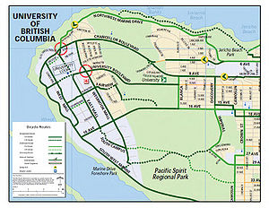
The UBC Point Grey campus is located at the westernmost point of the Broadway Corridor, within the university endowment lands. The official boundaries are defined by English Bay to the north, 16th Avenue to the south and Alma Street to the west end of the University Endowment Lands.[2]
More broadly, the Broadway Corridor is defined as the neighbourhoods through which Broadway runs through. The neighbourhoods are, from west to east, West Point Grey, Kitsilano, Fairview, and Mount Pleasant. Broadway runs in place of a 9th Avenue, between 8th and 10th.
History
The University of British Columbia was established in 1908, after the passing of British Columbia’s University Act. The location of the campus remained in question until 1910 when a government-appointed educationist commission decided upon the Point Grey site.[3] The site was a parcel of crown land that, at the time, consisted mainly of second growth forest. This particular site was chosen, as the commission noted, “because of its natural beauty and because its geography separated it from the growing urban center of Vancouver."[4]
Construction began on the Point Grey campus in 1914 but came to a halt during the First World War. After the war, construction slowly continued, and in 1925 UBC’s Point Grey campus officially opened to students.[5] Enrollment at the university rapidly increased after the Second World War and has continued to grow to the present day. With the increase in enrollment came the need for more facilities, services, and housing, which has led to the development of much of the University Endowment Lands.
The university is now attended by over 40,000 students and the surrounding endowment lands are home to over 7000 residents.[6]
University Endowment Lands Demographics
| Community Statistics Census Data | UEL (2001) | Metro Vancouver (2006) |
|---|---|---|
| Population | 7816 | 578,041 |
| Population change in 5 years | 14.4% | 5.9% |
| Age 19 and under | 22% | 17.9% |
| Age 20-64 | 67.7% | 69% |
| Age 65 and over | 10.2% | 13.1% |
| Households | 2874 | 253,210 |
| Median Household Income | $49,349 | $47,299 |
| Number of Families | 1815 | 145,605 |
| Total Employed Labour Force | 3565 | 310,640 |
Source: Statistics Canada 2006[7]
Current Transportation Infrastructure
UBC is currently served by 17 bus routes, including 6 express routes, the most utilized of which is the 99 B-Line. The 99 B-Line is a limited-stop express route that uses articulated buses to serve the Broadway Corridor from Commercial Station to UBC.
The university’s bus loop was recently moved to two temporary locations to increase capacity and allow for the construction of an underground transit exchange to begin. Plans for the underground exchange have since been put on hold, and the temporary bus loops continue to be used.
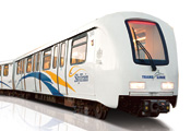
Metro Vancouver currently services three high-speed monorail rapid transit lines, which TransLink calls the SkyTrain. These lines are known as the Expo Line, the Millennium Line, and the Canada Line. The infrastructure required for rapid transit is generally very expensive, and while students and residents of the Broadway Corridor have been expecting easy access to a SkyTrain line sometime in the future, the plausibility of such is not likely.
The Issue: Rapid Transit Implementation
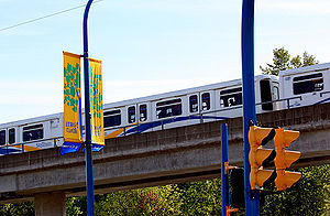
The Broadway Corridor is one of the busiest routes in all of North America. It is the second most traveled destination in the Lower Mainland, excluding Vancouver’s downtown core, which already contains two rapid transit Skytrain lines as part of its infrastructure. Broadway buses currently service 80,000 transit trips per day, comparable to today’s Canada Line ridership. The 2006 Census approximated that the Broadway Corridor contained 97,000 residents and 86,000 jobs. These numbers are rising. Current zoning plans allow for future growth potential within the corridor to add an additional 29,000 residents and 19,000 jobs by 2041.[8]
Along with Broadway corridor residents and commuters, UBC students using transit routes in the area has more than doubled in the past eight years due to the implementation of the U-Pass and student involvement in promoting public transit. Despite these incentives, however, only 27% of commuters to UBC arrive by transit[9] -- a number city developers hope to increase.
According to UBC AMS (UBC student society) President Ahmadian, "transit riders make more than 100,000 trips on the Broadway Corridor every day--more than the Canada Line or the Millennium Line. Fourty-four thousand of these trips go all the way to UBC." Thus, issues of overcrowded buses, high wait times, and insufficient service on the Broadway Corridor greatly impacts the UBC student community. It is estimated that 4,000 transit riders are left behind by full 99B-Line buses every day.
"It's not as if TransLink isn't trying to put the buses there," says Nancy Knight, Associate Vice President of Campus & Community Planning at UBC. "They are. But you just can't put enough buses there, which means you've got to move to the next level of capacity."[10]
Campaign for Rapid Transit
Due to these concerns, the AMS has launched a "UBClinenow" campaign to advocate a rapid transit solution before the problem worsens.[11] The AMS voiced concerns that the UBC student population has made great progress in embracing public transit since the implementation of the U-Pass and if it becomes too inconvenient to take transit due to congestion, crowded busses, and wait times these trends may shift back to automobile use. With UBC ridership expected to increase by 10% every year, these problems are only likely to worsen.[12]
UBC has recently made major adjustments to its on-campus transit infrastructure by relocating its bus loop. The old bus loop was reportedly too crowded and congested to support the increasing demand of public transit users. Current trends will inevitably create a similar situation for the new bus loop. For this reason, many UBC students believe that rapid transit solutions must be acted upon promptly.
Potential Solutions
TransLink has identified six potential solutions to increased transit service along the Broadway Corridor.[13] The first of these includes a more appropriate use of rapid buses (much like the already in place 99B-Line and 84 Lines), a light rail line, rail rapid transit (SkyTrain Line), or a combination of all three. To accommodate the increasing demand for rapid public transit, timely solutions are required. However, the proposed "Evergreen Line," which would provide extended SkyTrain service to Surrey (a neighbourhood to the Southeast of Vancouver's downtown), has risen as a competitor for funds for the proposed UBC line. Therefore, it is of UBC student concern to promote the UBC-line to Metro Vancouver as a project of equal or greater priority than the Evergreen Line. This is especially true since the UBC is the most commuted-to destination without a SkyTrain line.
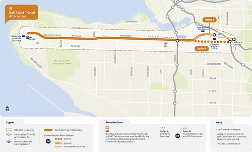
The most ambitious of the options which TransLink has identified is full SkyTrain service to the University of British Columbia. The University has been envisioned to be a rapid transit destination ever since 1985, and because the pedestrian-heavy Broadway corridor serves as the connecting spine to the Millennium Line, it has been assumed that SkyTrain access would eventually make its way to UBC. This option could cost up to $2.8 billion CAD.[14]
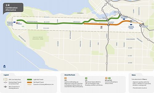
The second and less revolutionary option would be an extension of the Millennium Line to Arbutus Street, about two-fifths of the way to UBC. Because of the area west of Arbutus is less dense, it has been argued that a light-rail alternative would be a cheaper and more efficient alternative to full rapid transit service to the area. This alternative would include connections for UBC commuters to the Canada Line and the Millennium Line, and would allow one-transfer rides to UBC from any area.
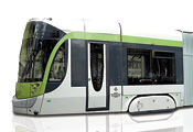
The third option would be to implement two light rail lines along Broadway. This option would be less advantageous since it would require those coming to or from the very dense Fairview region to make a transfer, thus limiting access to the neighborhood. Additionally, light rail lines might not be enough to satisfy the traffic demands along Broadway at peak hours. With ridership expected to be at 150,000 passengers per day, and buses facing overcrowding even when running every 90 seconds, a light rail line may not be able to operate at high enough capacity to provide a solution to the problem. Furthermore, a fully light rail line does not leave much room for future growth.
Technologies, Costs, and Convenience (March 30th, 2011)
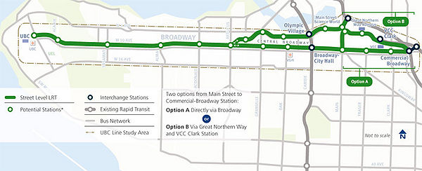
Between March 30th - April 22nd 2011 marks phase two of the 'UBC Line Rapid Transit Study'. The following options outline the proposed technologies for upgrades on Broadway Corridor Rapid Transit to UBC. Phase two is an era within the feasibility study to accumulate community opinion on which option is favored. Options involve: street-level light rail, underground rapid rail transit (similar to current 'Skytrain'), new bus technologies, a 'business as usual' approach that aims at improving current service and two combo's integrating several technologies.
| Technology | Travel Time - Bway Stn - UBC | Daily Boardings 2021 | Capital Costs | Incremental Operating Costs |
| Bus Rapit Transit Alternative - Diesel/Trolley | 33 min | 75 000 | $350M/$450M | $-1M/$-2M |
| Light Rail Alternative 1 (Option A/B) | 26 min/ 29 min | 99 000/109 000 | $1.18M/$1.18 | $-3M/$-6M |
| Light Rail Alternative 2 (Option A/B) | 26 min/29 min | 107 000/ 116 000 | $1.38M/$1.48M | $-3M/$-2M |
| Rail Rapid Transit Alternative (Option A/B) | 20 min/20 min | 137 000/ 146 000 | $3.28M/$2.98M | $-3M/$-7M |
| Combo 1 | 25 min | 145 000 | $2.48M | $-5M |
| Combo 2 | 32 min | 138 000 | $1.98M | $-4M |
| Best Bus Option | 30 min | 75 000 | $323M | $18M |
Rapid Bus Transit Alternative
Light Rail Alternative 1
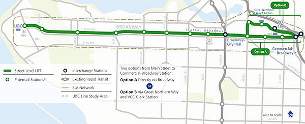
Light Rail Alternative 2
Rail Rapid Transit
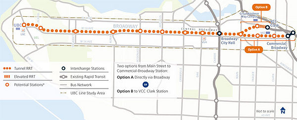
Combo 1
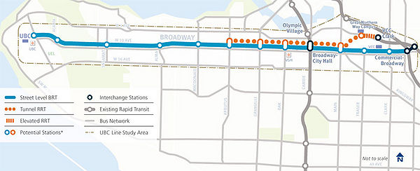
Combo 2
Challenges
Budget Concerns
TransLink, Vancouver's transportation service for Metro Vancouver, is currently facing a serious long-term budget gap[15], which threatens to interfere with plans to implement any new rapid transit lines. While city mayors are adamantly opposed to deficit plans which would cut bus service from the area, plans for rapid transit expansion may be hindered in the coming years.
Evergreen Line as a Competitor

Additionally, TransLink's proposed Evergreen Line threatens the potential construction of a transit line to UBC, as it serves as a competitor for funds. According to Translink:
- "The Evergreen Line is a new rapid transit line that will connect Coquitlam to Vancouver via Port Moody and Burnaby. The Evergreen Line will be a fast, frequent and convenient SkyTrain service, connecting Coquitlam City Centre through Port Moody to Lougheed Town Centre in approximately 13 minutes. It will connect without transfer to the current SkyTrain network at Lougheed Town Centre Station and will integrate with regional bus and West Coast Express networks. Construction of the Evergreen Line is anticipated to begin in early 2011 and be completed in 4 years."[16]
The Evergreen Line anticipates serving roughly 70,000 passengers per day.[17] This number pales in comparison to the expected service of a rapid transit line along the Broadway Corridor, which exceeds 100,000 passengers per day. For more info on the Evergreen Line, see www.evergreenline.gov.bc.ca.
NIMBYism and the UBC Line
Challenges from Residents
NIMBYism (Not in My Backyard-ism) is a significant challenge to city planning and policy[18] and a common hindrance of most municipal development projects. The UBC Line is no exception. The proposed UBC line will intersect two affluent, mid-to-low-density neighbourhoods on the western end of the route adjacent to UBC: Kitsilano and West Point Grey. During community consultation in 2009, members of the North West Point Grey Homeowners’ Association expressed concern about the UBC Line’s impact on their community. Residents stated that they identify their neighbourhood as a “village within Vancouver,” and are worried that the “community feel” of the area would be lost with the implementation of a rapid transit line. Residents cited potential increased densification around the UBC Line as one of their main concerns[19].
Challenges from Business Owners
Another issue stems from the fact that many local businesses lost income with the construction of the Canada Line, and many were forced to shut down. Businesses along the Broadway Corridor fear that history may be fated to repeat itself if construction of a rapid transit line within their neighbourhood (especially those directly in proximity of construction) commences. Kitsilano's Business and Residence Association for Sustainable Alternatives (BARSTA) stands adamantly opposed to the implementation of a SkyTrain line to their neighbourhood, fearing that their neighbourhood will experience a shutdown in the same fashion that other neighourhoods experienced with the implementation of the Canada Line.[20]
Concluding Discussion
Though rapid transit implementation into the UBC Point Grey campus remains one of the most heavily debated topics in the Metro Vancouver region, the benefits and demand are evident. As todays cities grow upward and outward the only way to make them functionable is if they are created as efficiently as possible. Transportation is at the center of this focus for designing future sustainable cities. Research shows public transit to be safer,cheaper,faster and therefore more efficient than private transit. The 'ecological footprint' left by big cities is also reduced when commuters leave their cars at home, especially when automobiles produce over 30% of Canada's greenhouse gas emissions.[21] Furthermore, since rapid transit increases public transportation ridership, it reduces the need for expansive parking lots, garages and wide roads -- thus allowing for more space for the city to utilize effectively.
The biggest challenges facing the UBC line are budget concerns. The most pressing question is whether or not Vancouver can afford to undertake another rapid transit project, especially one which requires such a large portion of the city's budget and time. Many believe that Vancouver should be spending its valuable taxpayers' dollars elsewhere, rather than on a transit line that less than half of the city's residents will be in a position to use.
However, if Vancouver wants to maintain its status as a sustainable city while achieving the same economic growth it has experienced in recent years, rapid transit along the city's busiest transit line is necessary. Vancouver's stated goal is to become the most ecological city in the world, yet this is assuredly unobtainable without extensive public transit growth to match the 13% ridership increase in the last 10 years.[22] The Broadway Corridor, as the city's most utilized transportation route, should be the obvious priority when it comes to sustainable transit: as such, it seems that the consensus amongst experts and officials is that the question is not if Vancouver should implement rapid transit, but when and how. Further studies will analyze which options are most sustainable and cost-efficient for the city, but the conclusion is clear: if Vancouver expects to grow as an ecological city, it must ensure that its transportation infrastructure along its busiest corridor services as many of its citizens as possible.
References/Footnotes
- ↑ Standing Committee Report on Transportation and Traffic." City of Vancouver, January 19, 2010. Web. 08 Feb 2011. <http://vancouver.ca/ctyclerk/cclerk/20100119/documents/ttra4.pdf>.
- ↑ "Vancouver Districts & Neighborhood Maps." Vancouver.com, n.d. Web. 08 Feb 2011. <http://www.vancouver.com/real_estate/relocation_tips/neighbourhoods_and_maps/>.
- ↑ A Brief History on the University of British Columbia." http://www.library.ubc.ca/archives/hist_ubc.html. University of British Columbia Library Archives, n.d. Web. 08 Feb 2011. <http://www.library.ubc.ca/archives/hist_ubc.html>.
- ↑ Norman, Emma Spenner. "Recovering the University Fabric: Point Grey Pre-University." University of British Columbia website, n.d. Web. 08 Feb 2011. <http://www.library.ubc.ca/archives/u_fabric/pre1890.html>.
- ↑ http://www.library.ubc.ca/archives/hist_ubc.html
- ↑ Statistics Canada. 2001 Community Profiles. 1 Feb. 2007. Web. 7 April, 2011. http://www12.statcan.ca/english/Profil01/CP01/Details/Page.cfm?Lang=E&Geo1=CSD&Code1=5915018&Geo2=PR&Code2=59&Data=Count&SearchText=University%20Endowment%20Area&SearchType=Begins&SearchPR=59&B1=Work&Custom=
- ↑ Statistics Canada. 2001 Community Profiles. 1 Feb. 2007. Web. 7 April, 2011. http://www12.statcan.ca/english/Profil01/CP01/Details/Page.cfm?Lang=E&Geo1=CSD&Code1=5915018&Geo2=PR&Code2=59&Data=Count&SearchText=University%20Endowment%20Area&SearchType=Begins&SearchPR=59&B1=Work&Custom=
- ↑ Grossman, Kate. "UBC Line Rapid Transit Study FAQ." 2009: n. pag. Web. 27 Feb 2011. < http://www.translink.ca/~/media/documents/bpotp/public_consultation/ubc_study/faq_and_common_definitions/ubc%20line%20rt%20study%20faq.ashx >.
- ↑ Standing Committee Report on Transportation and Traffic." City of Vancouver, January 19, 2010. Web. 08 Feb 2011. < http://vancouver.ca/ctyclerk/cclerk/20100119/documents/ttra4.pdf >
- ↑ See UBC Line Rapid Transit Study Analysis video at http://www.youtube.com/watch?v=0S0pf4BiOI4
- ↑ http://www.ams.ubc.ca/2010/10/ubc-students-launch-campaign-for-rapid-transit-now/
- ↑ UBC Students Launch Campaign for Rapid Transit Now." AMS Student Society Website . Web. 08 Feb 2011. <http://www.ams.ubc.ca/2010/10/ubc-students-launch-campaign-for-rapid-transit-now/>.
- ↑ Grossman, Kate. "UBC Line Rapid Transit Study FAQ." 2009: n. pag. Web. 27 Feb 2011. < http://www.translink.ca/~/media/documents/bpotp/public_consultation/ubc_study/faq_and_common_definitions/ubc%20line%20rt%20study%20faq.ashx>
- ↑ Burrows, Matthew. "Patrick Condon Highlights Cost of Broadway Traffic." Straight.com 24 Sep 2009: n. pag. Web. 11 Feb 2011. <http://www.straight.com/article-258880/condon-highlights-cost-broadway-transit>.
- ↑ Freemark, Yonah. "Vancouver's TransLink Faces Serious Funding Gap." Transport Politic 31 Jul 2001: n. pag. Web. 11 Feb 2011. <http://citationmachine.net/index2.php?reqstyleid=1&mode=form&reqsrcid=MLAMagazineOnline&more=yes&nameCnt=1>.
- ↑ www.evergreenline.gov.bc.ca
- ↑ www.evergreenline.gov.bc.ca
- ↑ Bunting, T., P. Filion, R. Walker, eds. Canadian Cities in Transition: New Directions in the Twenty-First Century. 4th ed.” Don Mills, Ontario. Oxford University Press. 2010. Print.
- ↑ “UBC Line Rapid Transit Study Consultation Session West Point Grey Resident & Community Groups”. Translink, 23 June, 2009. Web. April 7, 2011. www.translink.ca/.../ubc.../WP%20Grey%20Res%20Cmmnty%20Grp%20CS%20062309.ashx
- ↑ McElroy, Justin. "Kits. residents rally against a UBC Skytrain Line." Ubyssey Newspaper. 08 Aug 2010: n. pag. Web. 25 Feb 2011. <http://ubyssey.ca/news/point-grey-and-kits-residents-rally-against-a-ubc-skytrain-line/>
- ↑ http://www.york.ca/Services/Transit/The+Benefits+of+Rapid+Transit.htm
- ↑ Bunting, T, Filion P, Walker, R C (eds)(2010) Canadian Cities in Transition: New Directions in the Twenty-first Century (Toronto, Oxford University Press)
