Course:GEOG350/Archive/2010WT1/SouthRiverdaleToronto
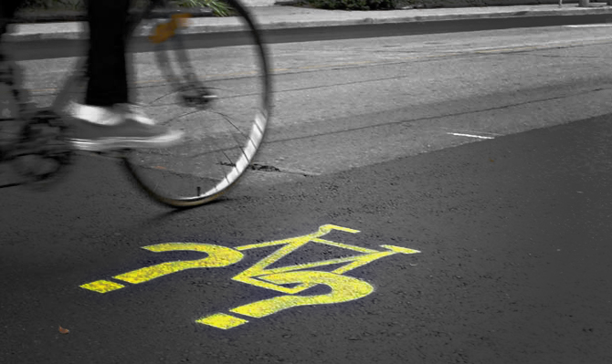
(Source: http://bikingtoronto.com/2010-toronto-cycling-map-adds-bike-boxes/)
We have chosen to investigate the neighbourhood of South Riverdale in Toronto and discuss cycling as an issue and alternative to other types of transit.
The origin of the bicycle dates back to the late 1700's, it's inventor is debated but often pinned as European inventor, interested in the movement of people and goods. Today what is not debated is the presences and popularity of the bicycle across the world. From the streets of Tokyo to the mountains of Peru, people the world round have been using the bicycle as a form of transit to travel from point A to B, and for hundreds of years and for the most part have been enjoying the ride.[1]
In modern times, and arguable modern cities, bicycles have become a way of life for some. They characterize their daily commute, their leisure time, a healthy, active lifestyle and a step towards promoting and maintaining 'livable' sustainable cities. On the opposite side, cycling as a form as transportation is seem for some, as an impediment, and obstacle on the road which must be aggressively run down and has no place in city centers.[2]
While these two camps fail to address all aspects of cycling they do set the stage for addressing transportation concerns in major cities. Below we will review the neighbourhood of South Riverdale in Toronto Ontario, and it's citizen's demands to improved access to major transportation routes running along the city's Lake Shore.
Transportation comes in many forms, this project and the citizen's of South Riverdale have chosen to discuss cycling as a relevant and sustainable method of transit. While transportation routes have the ability to create access we need to keep in mind that access to transportation routes are a major issue facing many neighbourhoods country wide. In South Riverdale, where access to cycling lanes has been highlighted as an area in need of improvement, there is space as well as a communal will to develop a cycle access route which will connect the neighbourhood southbound to the Lake Shore.
This article will exam the key factors contributing to the need for expansion of cycle path networks in the area, including demographics, local history, the underlying themes and challenges which have, thus far, kept this neighbourhood from enabling urban renewal and sustainable design principles.
South Riverdale: Ward 30 - Neighbourhood 70
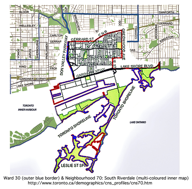
For election purposes, Ward 30 mainly covers three neighborhoods: North Riverdale(68), Blake Jones(69) and South Riverdale(70). These three neighborhoods are adjacent to each other and quite similar in nature. In 2006, Ward 30 was home to 51,235 people and consisted of 21,230 household. Ward 30 is 13 square kilometers in size.[3]
South Riverdale, neighbourhood 70, is located at the south end of the map of the City of Toronto. Neighbourhood 70 includes the Toronto Outer Harbor, which is an island that extends into Lake of Ontario.
Neighborhood Boundaries
- Northern boundary - Gerrard Street East, from Don Valley Parkway to Carlaw Avenue. Canadian National Railway, from Carlaw Avenue to Greenwood Avenue.
- Western boundary - Don Valley Parkway, from Gerrard Street East to Lake Shore Blvd East.
- Southern boundary - The Toronto Outer Harbor (Inclusive).
- Eastern boundary - Greenwood Avenue, from CNR to Queen Street East. Leslie Street, from Queen Street East to Lake Shore Blvd East.
Surrounding Neighborhoods
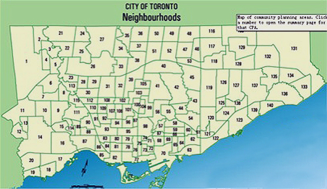
(Source: http://www.toronto.ca/demographics/profiles_map_and_index.htm)
South Riverdale is only 3-kilometers east to the Toronto downtown financial district – The Bay Street. South Riverdale is adjacent to the following neighborhoods: Waterfront Communities (77), Moss Park(73), Regent Park(72), North Riverdale(68), Blake Jones(69), Greenwood Coxwell(65), and the Beaches(63). South Riverdale is the only neighborhood has access to the Toronto Outer Harbor. Each year, the Toronto Inner Harbor, the Toronto Outer Harbor, and the Islands attract thousands of visitors worldwide in the summer.
History
Originally known as Riverside, Riverdale began as a small rural community, but was transported into the thralls of industry with the arrival of the railroad in the 1850s.[4] Industry brought an influx of workers who began to expand the community, and build their homes in Riverdale. Riverdale was annexed by Toronto in 1884, but it was not until the building of the Prince Edward Viaduct in 1918 that expansion really took off and Riverdale was able to connect with Toronto.[5]
South Riverdale was a classic "streetcar suburb" to Toronto, and the neighborhood was mostly developed by 1903. Much of the development that happened after this period and up until the mid-1920s was based around heavy industry, and consequently the neighborhood catered heavily to the working class.[6] Currently, South Riverdale is mainly a residential and commercial neighborhood with a small portion of light industrial properties.
Demographics
South Riverdale had a population of 24,430 as of 2006, which is the latest census available.[7] Out of this group, 63% of the population were of working age, 12% were youth and 14% were children. Seniors also accounted for a low 11% of the population. This type of data speaks to the high property value of this area, as there are clearly a lot more adults than children or youth, and child free adults are more able to afford expensive and desirable city housing than families with children, youth or seniors are. A large portion of the population of this neighbourhood has family incomes greater than $100,000/year (23-28%), and the average income of the neighbourhood, as collected from census in 2005, was $74,820.[8] This sort of data easily suggests that South Riverdale is a desirable and well-off neighbourhood, and also reflects the data on the age of this neighbourhood’s population, as young adults and elderly are much less likely to have high incomes than established, working adults are. South Riverdale has a higher male population than female with 12,305 males and 12,125 females.[9] Also, it is a community made up mostly of people of French and English descent (67%), but has a large Chinese descent population as well (23%). However, not many new immigrants settle in this area.[10] Perhaps this is due to the well-established nature of this neighbourhood, its desirability and high property values.
Characteristics of the Built Form
South Riverdale’s housing is, “a mix of charming Victorian and Edwardian brick semis and row houses, post-war stock and newer townhouses,” which is appealing to many city dwellers as a change from the monotonous building style of the suburbs.[11] Most housing is a mix of low- level apartment buildings, or apartments with less than 5 storeys, and semi-detached housing units.[12] South Riverdale is neighbourhood consisting mainly of older dwellings. This neighbourhood consist mainly of buildings built previous to 1946, with almost 6000 buildings remaining from this time period, and only 3730 buildings existing from after that time period.[13] Naturally, based on the age of these buildings and the nature of things to break down over time, much of South Riverdale is in a state of needed repair. An estimated 11% of this neighbourhood is in need of major repair, and 37% is in need of minor repair. South Riverdale also contains numerous parks and a lot of green space, making this area appealing to anyone who enjoys spending time outside.
Transportation Infrastructure
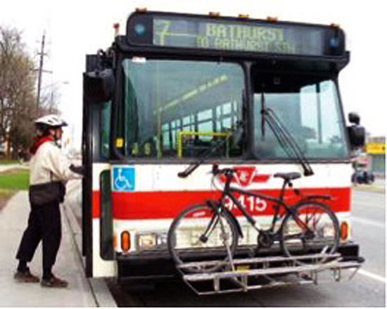
South Riverdale is a very desirable neighbourhood for commuters. Streetcars and buses are very commonly used by commuters in this area, as well as bike paths and various other forms of public transit. South Riverdale allows close access to the Don Valley parkway, Lakeshore Boulevard, and Gardiner Expressway, which are three major commuting veins for motor vehicle transport. There are also numerous bus routes through the neighbourhood which carry the “Rack it and Rocket” program, which puts bike racks on the front of buses, allowing for passengers to bring their bikes along with them.[14] This neighbourhood, like most in modern Canadian cities, is very vehicle-oriented and allows for motor vehicle access on all streets.
Public Transportation
Public transportation is quite convenient. Both historic streetcars and buses run in this neighborhood. Toronto Transit Commission schedules and adjusts the frequencies of streetcars and buses to meet the requirements of the residents.
Streetcar
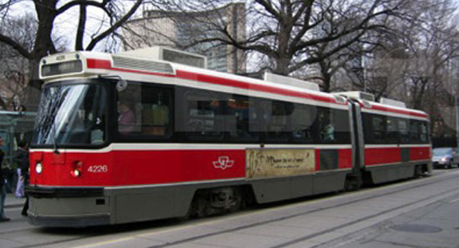
(Source: http://www.sitebits.com/photos/streetcar_toronto_1.html)
Streetcar started operation in 1920’s. Currently, four of the total twelve streetcar routes of the City of Toronto are in service for this neighborhood. Streetcars have one to three passenger compartments, depending on the numbers of the passengers on particular routes.
Bus
(Source: http://unorthodox-recumbent-bicycles.blogspot.com/2009/01/bus-bike-rack-dictates-basic-geometry.html)
Buses have one passenger compartment only. Some buses are equipped with bike racks to encourage cycling without paying an extra ticket. Toronto Transit Commission has been proposing the installation of bike racks to all buses of the City of Toronto.
Map of Public Transit of South Riverdale
(Source: http://www3.ttc.ca/images/fixedImages/TTCRideGuide_5.pdf)
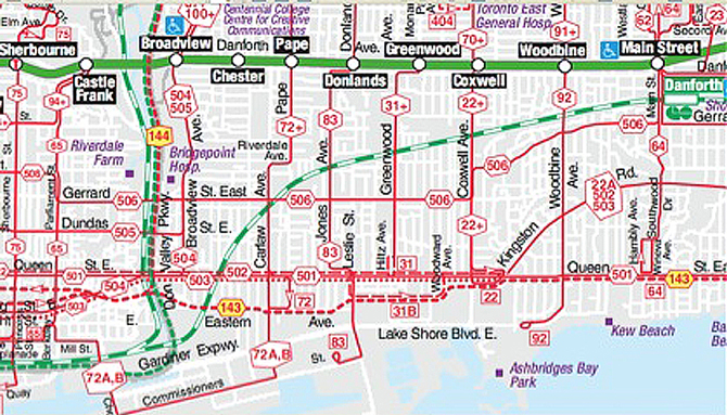
- West-East Direction has the following service lines:
Danforth Avenue – Bloor-Danforth Subway Line; Gerrard Street East – Street Car 506; Queen Street East – Street Car 501.
- North-South Direction has the following service lines:
Broadview Avenue – Streetcar 504, 505; Pape Avenue – Bus 72; Jones Avenue – Bus 83; Greenwood Avenue – Bus 31; Coxwell Avenue – Bus 22.
Cycling in South Riverdale
Downtown residents love recreational cycling to enjoy the beauty of the Lake Ontario. Currently, cyclists can bike along the existing Off-Road trail down to the Toronto Outer Harbor, which is identified as Lower Don Off-Road Trail in the Toronto Bike Plan. On the island, cyclists can bike on the existing Park-Road to experience the waterfront of Lake Ontario. This neighborhood has higher percentage of cyclists than other neighborhoods of Toronto for utilitarian purpose. For recreational purpose, this neighborhood also has more cyclists than other neighborhood because only this neighborhood has existing Off-Road trail along Lake Shore Blvd East, as well as access to the Toronto Outer Harbor through existing Park Road trail. Residents of adjacent neighborhoods make use of the Lower Don Off-Road and Park-Road trails for recreational purposes. In Ward 30, 49% of the workers travel to work by auto, 38% of the workers travel to work by transit, 13% of the workers travel to work by bike or walking. Compared with the City of Toronto, 62% of the workers travel to work by auto, 30% of the workers travel to work by transit[15], 8% of the workers travel to work by bike or walking.
Existing Bike Trails of Ward 30
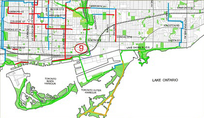
The boundary of Ward 30 is quite consistent with existing bike trails. On the northern boundary, Danforth Ave has an existing Bike Lane or Signed Route, from Don Valley Parkway to Jones Ave(the red and blue lines). On the western boundary, an existing Off-Road trail runs with the Don Vally Parkway(the green line). On the southern boundary, the Off-Road trail extends out to the Toronto Outer Harbour(the green line), where is mainly Park-Road for biking(the yellow line). On the eastern boundary, there is no bike trail. However, in the middle of the neighborhood, a north-south direction road - Jones Ave has existing Bike Lane on both directions, which runs from Danforth Ave to Queen Street East.
- West-east Direction:
- Danforth Avenue - Gerrard Street East - Dundas Street East - Queen Street East - Eastern Ave
Danforth Avenue runs the same route as the Bloor-Danforth subway line. East China Town covers from Gerrard Street to Queen Street East. Cycling on Dundas Street East and Queen Street East is more popular than other streets. Eastern Ave seems to have lower density of residential and commercial properties than other streets.
- North-South Direction:
The Lower Don Off-Road bike Trail, connecting with two other Off-Road Trails of Toronto, runs along with Don Valley Parkway down to Toronto Outer Harbor. Cyclists mainly bike on this trail for recreation. Jones Avenue provides with an existing bike lanes for both directions. Cycling on Jones Avenue can be both recreational and utilitarian.
(Source: http://biketoronto.ca/topic/show/Bikeway%20Network)
The Major Issue: Unsatisfactory Cycling Access Routes of South Riverdale
The issues presented in Toronto’s South Riverdale current transportation infrastructure, lie in the cycling access routes. Connection from the neighbourhood down to the waterfront (Lake Ontario) and Lakeshore Blvd’s Multi-use pathway (includes bike lanes) is of the largest concerns for the South Riverdale neighbourhood (Paul Young, Bike Union, Friends of the Spit, tcat.org).[16]
Along Lake Ontario a Major Multi-use pathway connects the city’s waterfront, heading east-west along Lakeshore Blvd. Unfortunately South Riverdale lacks secure and designated bike lanes connecting to this route, which would grant access not only to the waterfront transit infrastructure, but also to Tommy Thompson Park and Cheery Beach Park.
Advocacy Within The Community
Neighbourhood associations including the South Riverdale Community Health Center (SRCHC) and pedestrian and cycle unions, are currently coordinating their efforts to have a designated bike running north- south to connect to their community with the lake front (Lake Ontario).
Part of this issue also lies in determining the best route for new cycle lanes and harmonizing the community’s recommendations with the city of Toronto and the Toronto Transit Commission’s infrastructure plans.
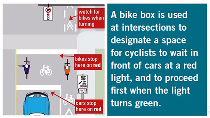
The efforts of local advocates such as SRCHC, Bike Sauce and the Pedestrian and Cycle Union, to name a few, have pushed this issue into the forefront of their community action plans simply because it matters to their residents. These groups have fought to ensure not only the safety of cyclists in the city but also to increase access and accessibility of the cycle routes. The development of bike boxes, which where implemented sparingly around the city in the early spring and summer, came as a result of the advocacy and coordination of these groups.
(Source: http://bikesauce.org/)
Working through municipal action plans like the Bikeway Network Project (http://www.toronto.ca/cycling/network/network-project-status.htm) Bike Sauce and SRCHC (among others) have slowly been able to gain the attention of city planners and Councillors to highlights the need and wants of local active citizens. For now the next project of these community orient organizations is creating safe cycle access to the Lakeshore in the South Riverdale neighbourhood.
It has become an issue worth analyzing as residents are increasingly demanding access not only to recreational areas, but also improved cycling infrastructure for commuting and recreational means. If a neighbourhood does not present the collective will or concerns of its residents, then what in fact does it represent?
Worth
We believe this topic is worth analyzing because it explores how transit routes impact a population and where improvements can be made. Increasingly the access and mobility of neighbourhoods are impacting the livability of the area and defining the character which a neighbourhood takes on. Using South Riverdale as a case study and investigating how invested the South Riverdale neighbourhood is in bicycle access, helps us to understand to the abilities of neighbourhoods en mass.
While South Riverdale is included in the City of Toronto's Bikeway Network, which is working to build and maintain functional cycle lanes across the city, there is a considerable need to update and expand these access routes to meet the needs and wants of citizens. In South Riverdale where a community is bombarded with auto access routes, commuter traffic and drive for improved transit conditions, action must be taken and voices must be heard.
Meeting The Criteria of Toronto's "Bike Plan"
Furthermore resolution of this issue is increasingly imperative in order to fill the gap of safe, secure cycling infrastructure and to compile with the City of Toronto’s own “Bike Plan”. The Bike Plan highlights the “spokes” which the plan encircles.
Three of these spokes include:
- Bicycle friendly streets.
- A bikeaway network- which should connect all cycling routes for commuter and recreational use
- Safety and education of cyclists and motorists alike. Connecting South Riverdale with Lakeshore’s Multi-use recreational pathway will fill this gap and stands to engage the health initiatives of the community aimed at improving the physical and mental wellbeing of the neighbourhood (Young, SRCHC)
While the residents of the South Riverdale neighbourhood are primarily impacted by the lack of cycle connection to the waterfront, the impacts of a new bike lane and increased access to the waterfront stands to benefit a greater population. In connecting the heart of South Riverdale with a Major Multi-use pathway along the Lakeshore, it opens access to increased mobility to and from Riverdale. Residents from other neighbourhoods in the GTA who are connected to the cycle routes, will have a better and safer opportunity to explore and return to Riverdale community and vice versa.
Through the analysis provided by our investigation we maybe able to improve the options and availability of cycle routes within the South Riverdale neighbourhood. Thereby, not only impacting the larger transportation infrastructure of Toronto, but also improving and developing new models for citizen and community action within Canadian cities.
Underlying Causes of The Major Issue
In order to combat the issue of making cycling more accessible in the South Riverdale neighbourhood, we must first tackle the factors behind it.
There are three major factors affecting the implementation of a complete bikeway network in South Riverdale:
- Transition of Transportation
- “15-minute Exit Ramp Economy vs. A 20-minute Neighbourhood”
- Decision-Makers in Urban Planning.
Transition of Transportation
Since the early 20th Century, there was an overall heightened demand for consumption. Such growth in the communities relied heavily on automobile usage, which in turn influenced suburban sprawl. Transportation allowed for low density and specialized land usage. Furthermore, automobile dominance introduced big shopping malls and suburban configurations alike.[17]
In a vibrant neighbourhood such as South Riverdale, according to City of Toronto Ward Profiles 2006 Travel Characteristics, there are 1.3 licensed drivers per every household and 0.9 vehicles per every household. Moreover, residents use vehicles more for non-work related trips (56%) than for work related trips (49%). This may be due to the convenience of “power mall” shopping outside of the neighbourhood (ward). Work trips are mainly focused on the outside of the ward and within Toronto area (89%), which may be a reason for higher percentage of alternative transportation being utilized (Transit 38%, Others 13%). South Riverdale is very well connected by public transportation (street car). Thus, it is only logical to use public transportation to commute to work and potentially avoid the sky-high parking rates of Toronto.
15-minute Exit Ramp Economy vs. A 20-minute Neighbourhood
Due to such dispersed urban infrastructure of the 1950’s, urban dynamics within the city have changed significantly. City planners have been using a “15-minute Exit Ramp Economy” strategy to build neighbourhoods in and around the city.[18] With the suburban lifestyle on the rise, the key was proximity to the expressway; no more than 15 minutes drive from the exit of an expressway. As a result, traffic engineers had only one goal in mind – to accommodate the rising automobile dependency. As such, sustainability was out the door.
In today’s modern neighbourhood of South Riverdale, we are facing significant issues concerning unsafe traffic conditions and overall perceptions of urban sustainability. The key factor behind this issue seems to be proximity. If South Riverdale were a denser neighbourhood, comprised of all needs and wants of its citizens, there would be less need to use vehicle for travel within and outside the ward.[19]
Andrew James, a candidate councillor (and a cyclist) for the 2010 Elections (Ward 30), strongly urges urban planning to focus on densification as an answer to sustainability: “A huge part of the sustainability puzzle is densification. Instead this city is concentrating its new residential development down by the lake, where there currently is no transit and won’t be for over half a decade".[20]
A “20-minute Neighbourhood” encourages people to imagine all their needs and wants within their neighbourhood. Mayor Sam Adams of Portland, Oregon is on a serious quest to implement this idea in his city. Mayor Sam Adams suggests that it takes 20 minutes to walk a mile or 1.6km, which should be an indicator for businesses to flourish within these guidelines.[21]
Business owners in Toronto's core seem to agree with Mayor Sam Adams of Portland. The survey of Toronto's downtown core business owners' views about new bike lanes showed that "nearly 75 per cent thought their business would stay the same or improve, while just over 25 per cent thought the change would bring in fewer customers[22]."
On the other hand, however, in Vancouver, BC - Hornby Street business owners were the main opposition to the new bike lane construction due to a belief that it will dangerously affect their business: "A survey by the Canadian Federation of Independent Business found that 92 per cent of business owners on Hornby expect a negative impact from the bike lane with an average loss in sales of 23 per cent, or $83,000 a year, per business[23]."
The differing views of these cities only prove that sustainability is not as easy as it looks on paper. It is extremely difficult to direct residents' and officials' views into the direction of urban sustainability. However, with a little shift in the mind set, everyone will soon benefit from a life without automobile dependency. Furthermore, moneys will stay in the communities and its residents will benefit from higher living standards and healthier lives by engaging in walking and/or biking.
Decision-Makers in Urban Planning
Regardless of how much change one community asks for, it is up to community’s decision-makers to have a final say in the implementation. To even think of future urban planning, a plan has to make economic sense first and then satisfy other requirements. In other words, if there is no budget to put forward, it is difficult to change anyone’s 1950’s car-dependent mind-set.
With the population on the rise and a much larger future city, South Riverdale faces uncertainty in consensus over common lifestyle. Media has already created a war between cyclists and motorists via displays of car-bike violence and more than frequent collisions.[24] What most people do not see is how to make roads more bike-friendly instead of separating the neighbourhood’s residents into two groups. Even the politicians are placed in two groups known as pro- or anti- cycling.[25]
South Riverdale’s very own self-proclaimed “pro-cycling” councillor, Paula Fletcher, made a mistake of her own when she “accidentally” voted ‘NO’ on a University bike lane pilot project (a summer tryout) changing the outcome of the project completely. She claimed she was feeling fatigue and thus misrepresented her answer.[26] Her “wrong” answer cost commuters a much needed bike lane and a pro-active move towards a more sustainable city. More alarming is the fact that one third of councillors skipped the voting altogether.[27] This only proves that our issue at hand is not a priority where it counts most. Many politicians like Paula Fletcher drive SUV’s to work and are certainly not in a position to propose plans and prepare educational material when it comes to the issue of sustainable transportation. Establishing a complete bikeway network in South Riverdale requires listening to tired voices of South Riverdale community of daily commuters and cyclists, rather than only going by decision-makers’ agendas. If we learned anything from Vancouver, BC’s recent ambitious cycling project it would be easy to conclude that budget should not be an issue to building a more sustainable city. To put it into a clearer perspective, “[the] average cost of installing motor vehicle infrastructure is $1 million/block,” where as Vancouver’s Hornby Street project extending 2.4km cost only $3.2 million.[28]
Our Recommendation/Solution
Cost Benefit Analysis
While the neighbourhood has already begun to plant seeds for sustainable environmental development, there needs to be consideration for the holistic functioning of the community and this includes considering practices of sustainable economic development. Fortunately for the South Riverdale neighbourhood, a major roadway reconstruction is being planned for a North-South access route. In combination with the Toronto Transit Commission (TTC) and the City of Toronto, Leslie Street South will be torn up and repaved to accommodate for public transit vehicles. This provides the neighbourhood and the city with the opportunity create safe and accessible cycle lanes while minimizing costs as the projects can be completed in tandem. While this solution seems a perfect match, it has been a challenge for community advocates to have their voices heard in this building project. Questions of responsibility in terms of maintenance and property come into question as the TTC and the City of Toronto grapple with access, zoning regulations and cost sharing concerns.
It has been a tedious municipal battle to allocate responsibility in the redevelopment of the Leslie Street South roadway. Local activism and representatives will need continuous support from their neighbourhood as well as invested citizens to keep this proposal alive and on the beat of increasing the accessibility of transportation to and from the Lake Shore. Finally, the political workings of the City of Toronto at large will undoubtedly play a role in all future development projects. The City of Toronto has recently elected aggressively Conservative Mayor who has formally stated his plans to not only tear out kilometers of public transit rail lines through the city, but also do his best to ensure that bicycles are kept in the suburbs and out of 'his' city.[29] While the new Mayor in town has an entire City Council and a small army of local advocacy groups to work for before instigating any major changes, the impact a single politician can have on a city's design must not be over looked.
Whatever happens in South Riverdale's quest for safe and accessible cycling lanes, may speak for more than the urban redevelopment process of a single neighbourhood. The outcome here has the ability to set a precedent, to build a solution. For now time will be the judge as to whether the decisions, the designs and the city are sustainable or not.
The Toronto Cyclists Handbook
Please brush up on your cycling etiquette by downloading this very informative Toronto Cyclists Handbook (courtesy of Toronto Cyclists Union @ http://bikeunion.to/) from: http://bikeunion.to/sites/default/files/handbook/cyclists_handbook_eng.pdf
Closing Remarks
Cycling is a Lifestyle. Hopefully we have inspired you to think outside the box and accept cycling as a great way of saving your health and our planet...while travelling from point A to point B.
- Thank You for taking time to read through our project. We leave you now to enjoy this awesome video and some pretty funky tunes (courtesy of Vuelo Velo on Vimeo):
http://player.vimeo.com/video/9653206
(Source: http://bikingtoronto.com/ibiketo/)
REFERENCES:
- ↑ Britannica Encyclopedia
- ↑ bikesauce http://bikesauce.org/
- ↑ City of Toronto Ward Profiles, 2006 http://www.toronto.ca/wards2000/ward30.htm
- ↑ Our Home Riverdale.http://www.ourhometoronto.com/neighbourhoods/riverdale/
- ↑ Our Home Riverdale.http://www.ourhometoronto.com/neighbourhoods/riverdale/
- ↑ Walks, A., 2008
- ↑ Age and Gender.http://www.toronto.ca/demographics/cns_profiles/cns70.htm
- ↑ Income and Poverty.http://www.toronto.ca/demographics/cns_profiles/cns70.htm>
- ↑ Age and Gender.http://www.toronto.ca/demographics/cns_profiles/cns70.htm
- ↑ Language and Ethnicity.http://www.toronto.ca/demographics/cns_profiles/cns70.htm
- ↑ South Riverdale.http://www.torontolife.com/guide/real-estate/east/south-riverdale/
- ↑ Families and Dwellings.http://www.toronto.ca/demographics/cns_profiles/cns70.htm
- ↑ Families and Dwellings.http://www.toronto.ca/demographics/cns_profiles/cns70.htm
- ↑ TTC Ride Guide.http://www3.ttc.ca/images/fixedImages/TTCRideGuide_5.pdf
- ↑ City of Toronto Ward Profiles 2006, page 14.http://www.toronto.ca/wards2000/pdf/2006/ward30_2006profiles.pdf
- ↑ www.tcat.org
- ↑ Bunting,2010
- ↑ Bunting, 2010.
- ↑ James, 2010.http://jamesinward30.com/platform/
- ↑ James, 2010.http://jamesinward30.com/platform/
- ↑ Sommerfeld, 2010.
- ↑ Enchin, 2010.
- ↑ Enchin, 2010.
- ↑ Richardson, 2010.
- ↑ Alcoba, 2010.
- ↑ Alcoba, 2010.
- ↑ Alcoba, 2010.
- ↑ Enchin, 2010.
- ↑ Globe and Mail http://www.theglobeandmail.com/news/national/toronto/rob-ford-and-a-decade-of-controversy/article1678543/
1. “Age and Gender.” South Riverdale neighbourhood profile: City of Toronto. Oct 15, 2010 <http://www.toronto.ca/demographics/cns_profiles/cns70.htm>
2. bikesause. Retreived Dec 3rd 2010. http://bikesauce.org/
3. Britannica Encyclopaedia. Retreived Dec 3rd 2010. http://www.britannica.com/EBchecked/topic/64721/bicycle
4. Bunting, Trudi. Canadian Cities in Transition Fourth Edition. Don Mills, Ont: Oxford UP, 2010. Print. 30-31, 42-43, 80-83.
5. Bunting, Trudi. Canadian Cities in Transition Fourth Edition. Don Mills, Ont: Oxford UP, 2010. Print. 191-192,
6. Canada. City of Toronto. Planning. The Toronto Bike Plan. By City of Toronto. Web. 24 Sept. 2010. <http://www.toronto.ca/cycling/bikeplan/pdf/bike_plan_brochure.pdf>.
7. City of Toronto Ward Profiles, 2006. Retrieved Oct 13th 2010. http://www.toronto.ca/wards2000/ward30.htm
8. City of Toronto Ward Profiles 2006, page 14. Retrieved Oct 13th 2010. http://www.toronto.ca/wards2000/pdf/2006/ward30_2006profiles.pdf
9. David Nickle. (2006, July 6). Fine-tuning bike lanes will help everyone, councillor says :[Final Edition 1]. The East York Mirror,p. 01. Retrieved October 09, 2010, from Canadian Newsstand Complete. (Document ID: 1073014011).
10. “Families and Dwellings.” South Riverdale neighbourhood profile: City of Toronto. Oct. 15, 2010 < http://www.toronto.ca/demographics/cns_profiles/cns70.htm>
11. Harvey, Enchin. (2010, October 5). Hornby St. fracas shows bike lanes need better PR. The Vancouver Sun, A.4. Retrieved October 13, 2010. <http://www.vancouversun.com/travel/Hornby+fracas+shows+bike+lanes+need+better/3624335/story.html>
12. “Income and Poverty.” South Riverdale neighbourhood profile: City of Toronto. Oct. 15 2010 <http://www.toronto.ca/demographics/cns_profiles/cns70.htm>
13. James, A. (2010, October 10). Candidate website. Retrieved from http://jamesinward30.com/platform/
14. Jessica Barrett. (2010, September 15). NEWS: Debate over downtown bike lanes continues. WestEnder, 8. Retrieved October 13, 2010, from Canadian Newsstand Complete. (Document ID: 2139285551).
15. “Language and Ethnicity.” South Riverdale neighbourhood profile: City of Toronto. Oct. 15, 2010 < http://www.toronto.ca/demographics/cns_profiles/cns70.htm>
16. Lorraine Sommerfeld. (2010, September 25). A 20-minute city plan. Toronto Star, W.2. Retrieved October 10, 2010, from Canadian Newsstand Complete. (Document ID: 2147298901).
17. Mark Richardson. (2010, September 18). Breaking the cycle of car-bike violence: Four years after her husband's death, woman behind Share the Road finds some peace. Toronto Star, W.33. Retrieved October 10, 2010, from Canadian Newsstand Complete. (Document ID: 2141818521).
18. Natalie Alcoba. (2010, May 14). Third of councillors skip bike-lane vote; Proposal Defeated. National Post, A.10. Retrieved October 09, 2010, from Canadian Newsstand Complete. (Document ID: 2034543481)
19. “Our Home Riverdale.” Our Home Toronto.com. Oct 16, 2010 <http://www.ourhometoronto.com/neighbourhoods/riverdale/>
20. “South Riverdale.” Torontolife.com. Oct 15, 2010 < http://www.torontolife.com/guide/real-estate/east/south-riverdale/>
21. "South Riverdale Cycle Review with Paul Young of South Riverdale Community Health Center." Personal interview. 30 Sept. 2010.
22. Tess Kalinowski. (2010, October 11). WHAT IS WRONG AND HOW IT COULD BE FIXED. Toronto Star, GT.2. Retrieved October 09, 2010, from Canadian Newsstand Complete. (Document ID: 2159047941).
23. Toronto’s Vital Signs 2010. (2010, October 5). Toronto Star, R.4. Retrieved October 13, 2010, from Canadian Newsstand Complete. (Document ID: 2154226851).
24. “TTC Ride Guide.” Toronto Transit Commission. Oct 16, 2010 <http://www3.ttc.ca/images/fixedImages/TTCRideGuide_5.pdf>
25. Walk, cycle to fight obesity: study. (20 August). The National - CBC Television. Retrieved October 10, 2010, from CBCA Reference and Current Events. (Document ID: 2116089231).
26. Walks, A. and August M., "The Factors Inhibiting Gentrification in Areas with Little Non-market Housing: Policy Lessons from the Toronto Experience Urban Studies" November 2008 45: 2594-2625.
