File:Tahltan Map 2.jpg
No higher resolution available.
Tahltan_Map_2.jpg (408 × 239 pixels, file size: 48 KB, MIME type: image/jpeg)
Summary
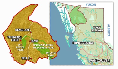
| Description | English: A map displaying the boundaries of Tahltan Traditional Territory on the Provincial scale |
| Date | 1 December 2017 () |
| File source | https://warriorpublications.wordpress.com/2013/08/16/tahltan-first-nation-tells-fortune-minerals-to-leave-their-traditional-territory-elders-insist-klappan-region-be-made-a-protected-area/ |
| Author | Warrior Publications |
Licensing
{{subst:uwl}}
File history
Click on a date/time to view the file as it appeared at that time.
| Date/Time | Thumbnail | Dimensions | User | Comment | |
|---|---|---|---|---|---|
| current | 22:09, 1 December 2017 | | 408 × 239 (48 KB) | NicholasNieuwenhuis (talk | contribs) | User created page with UploadWizard |
You cannot overwrite this file.
File usage
The following page uses this file: