File:Nusfjord road, 2010 09.jpg
Size of this preview: 800 × 327 pixels. Other resolutions: 320 × 131 pixels | 640 × 261 pixels | 1,024 × 418 pixels | 1,280 × 523 pixels | 4,500 × 1,838 pixels.
Original file (4,500 × 1,838 pixels, file size: 8.09 MB, MIME type: image/jpeg)
Summary
| Description |
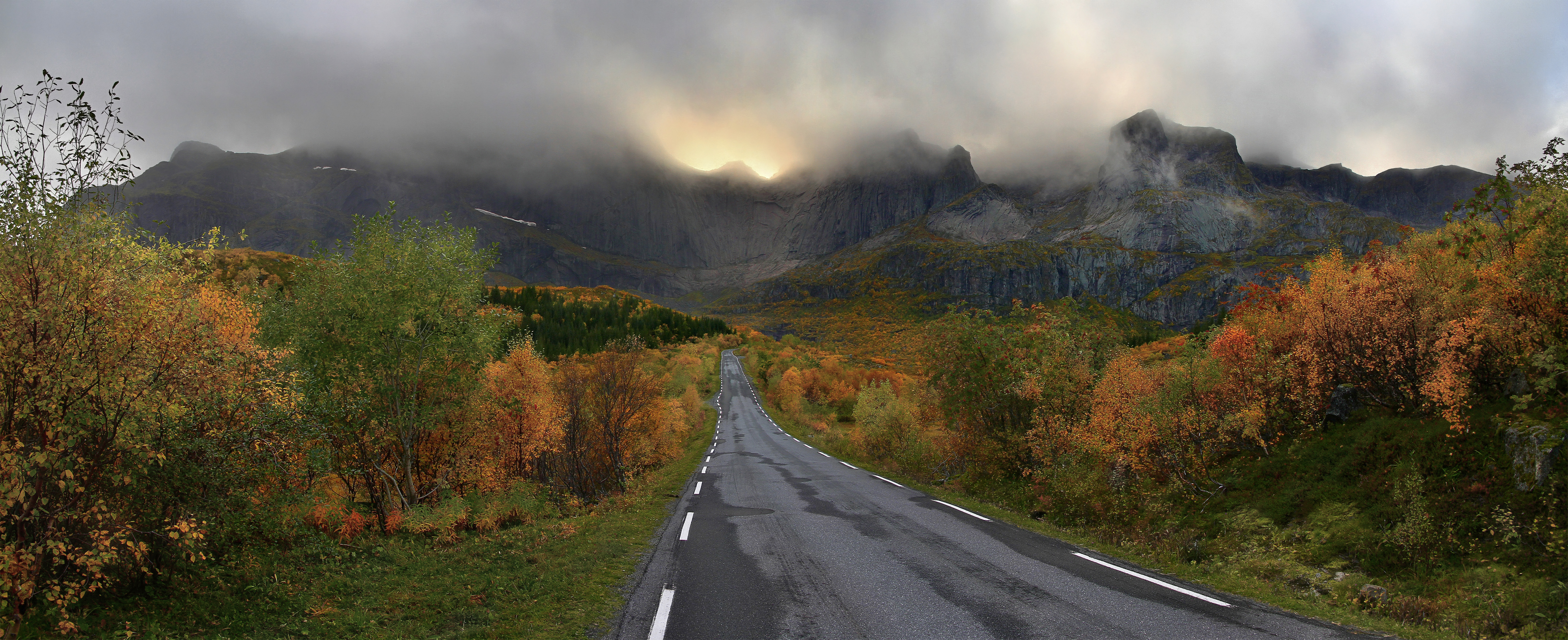
English: A mountain massif of Flakstadøya island backgrounding the road (Fylkesvei 807) to Nusfjord village, Lofoten, Nordland, Norway in 2010 September. For example, there are such summits as Stjernhauet, Stjerntinden, Bjørntinden and Sautinden either visible or nonvisible due to the cloud situation. Français : Le massif montagneux de l'île de Flakstadøya apparaît en arrière-plan de la route Fylkesvei 807 qui se rend au village de Nusfjord en Norvège. Photo prise en septembre 2010. Nederlands: Zicht op de weg naar Nusfjord, behorende tot de gemeente Falkstad op de Lofoten. Македонски: Планински масив на островот Флакстадеја и патот кон селото Нусфјорд, Норвешка. Русский: Горный массив на острове Флакстадоя, Лофотенские острова, Норвегия, сфотографированный с дороги на Нусфьорд. This file was uploaded with Commonist. |
| Date | |
| Source | Own work |
| Author | Ximonic, Simo Räsänen |
| Camera location | | View this and other nearby images on: OpenStreetMap |
|---|
| Annotations | This image is annotated: View the annotations at Commons |
Licensing

|
Permission is granted to copy, distribute and/or modify this document under the terms of the GNU Free Documentation License, Version 1.2 or any later version published by the Free Software Foundation; with no Invariant Sections, no Front-Cover Texts, and no Back-Cover Texts. A copy of the license is included in the section entitled GNU Free Documentation License. |
Assessment
|

This image was selected as picture of the day on Wikimedia Commons for 19 October 2011. It was captioned as follows: English: A mountain massif of Flakstadøya island backgrounding the road (Fylkesvei 807) to Nusfjord village, Lofoten, Nordland, Norway in 2010 September. For example, there are such summits as Stjernhauet, Stjerntinden, Bjørntinden and Sautinden either visible or nonvisible due to the cloud situation. Other languages:
Dansk: Bjergmassiv på Flakstadøya som baggrund for vejen (Fylkesvei 807) til Nusfjord, Lofoten, Norge i september 2010. Toppene Stjernhauet, Stjerntinden, Bjørntinden og Sautinden er enten synlige eller usynlige som følge af skydækket. Eesti: Mäemassiiv Norras Nordlandi maakonnas Flakstadøya saarel. English: A mountain massif of Flakstadøya island backgrounding the road (Fylkesvei 807) to Nusfjord village, Lofoten, Nordland, Norway in 2010 September. For example, there are such summits as Stjernhauet, Stjerntinden, Bjørntinden and Sautinden either visible or nonvisible due to the cloud situation. Español: Un macizo montañoso de la isla Flakstadøya al fondo de la carretera (Fylkesvei 807) al pueblo de Nusfjord (Lofoten, Nordland, Noruega) en septiembre de 2010. En él hay cimas como Stjernhauet, Stjerntinden, Bjørntinden y Sautinden, visibles o no según la ubicación de las nubes. Français : Le massif montagneux de l'île de Flakstadøya apparaît en arrière-plan de la route Fylkesvei 807 qui se rend au village de Nusfjord en Norvège. Italiano: Un massiccio montuoso dell'isola Flakstadøya visto dalla strada "Fylkesvei 807" verso il villaggio di Nusfjord, contea di Nordland, Norvegia, settembre 2010. Nederlands: Een bergmassief op het eiland Flakstadøya, met op de voorgrond de weg Fylkesvei 807 richting Nusfjord, Lofoten. Română: Un masiv muntos de pe insula Flakstadøya în fundalul drumului (Fylkesvei 807) către satul Nusfjord, Lofoten, Nordland, Norvegia, în septembrie 2010. Există piscuri, precum Stjernhauet, Stjerntinden, Bjørntinden și Sautinden, fie vizibile sau nevizibile în funcție de situația norilor. Русский: Горный массив на острове Флакстадоя, Лофотенские острова, Норвегия, сфотографированный с дороги на Нусфьорд в сентябре 2010 года Українська: Гірський масив острова Флакстадея (норв. Flakstadøya) на задньому плані повітової дороги 807 в напрямку до села Нусфіорд, Лофотенський архіпелаг, Норвегія, вересень 2010 р. Деякі вершини невидимі через хмарність. 日本語: 2010年9月、ノルウェー・ヌールラン県ロフォーテン諸島のヌースフィヨルド村へ続く国道807号線とフラックスタッド島の山塊。 中文: 挪威罗弗敦群岛法尔克斯塔德阿岛风景。 |
This image has been assessed using the Quality image guidelines and is considered a Quality image.
|
File history
Click on a date/time to view the file as it appeared at that time.
| Date/Time | Thumbnail | Dimensions | User | Comment | |
|---|---|---|---|---|---|
| current | 22:57, 1 April 2012 | 4,500 × 1,838 (8.09 MB) | wikimediacommons>Ximonic | Gamut check, careful noise reducal |
File usage
The following page uses this file: