File:LFS 350, group 1, soil data, table.png
No higher resolution available.
LFS_350,_group_1,_soil_data,_table.png (728 × 225 pixels, file size: 0 bytes, MIME type: image/png)
Summary
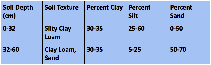
| Description | English: Figure D2: Soil Fraction of different horizons of the thistle down field. The soil fraction was determined by interpreting the soil texture using Minasny’s classifications, especially those in Table 1 (Minasny, 2007). |
| Date | 3 December 2014 |
| File source | Own Work |
| Author | ElisabethBarrows |
Licensing
|
File history
Click on a date/time to view the file as it appeared at that time.
| Date/Time | Thumbnail | Dimensions | User | Comment | |
|---|---|---|---|---|---|
| current | 04:54, 4 December 2014 | 728 × 225 (0 bytes) | ElisabethBarrows (talk | contribs) |
You cannot overwrite this file.
File usage
The following page uses this file: