Course:COGS200/2017W1/Group29FinalProject
Introduction
You are rushing through the mall at 4:50pm on Christmas Eve, searching for Toys ‘R Us, knowing it closes in 10 minutes. You never come to this mall because it is so challenging to locate anything and all you want is to find an information kiosk to assist you. You can not find the kiosk, the Toys ‘R Us closes, and you are unable buy the presents your children had asked for.
It is crucial that public spaces, such as shopping malls, are easy to navigate. An uncomplicated environment where individuals can easily find common points of interest, being bathrooms, information kiosks and food courts, allow for the shopper to have a positive experience. With time efficiency being essential in the modern society, individuals are less incentivised to go to a shopping centre where they are likely to become disorientated or lost, as this would take time from their busy schedules. Additionally, if an environment is difficult to navigate, it can make the entire experience unpleasant and reduce the likelihood of returning (Carpman & Grant, 2002). From the perspective of the proprietor of a public space, other studies have found that in confusing environments, staff were forced to spend a large proportion of their time not working, but giving directions to disoriented patrons (Rooke, Koskela, & Tzortzopoulos, 2010).
In this experiment, wayfinding skills and virtual reality (VR) will be incorporated to effectively test environments for functionality through experimental manipulation of points of interest, allowing planners to optimize layouts prior to formal design. Wayfinding is the method in which people navigate environments. Understanding how people move through space and determining the fastest route will provide valuable data for the design of certain environments. The psychological study of wayfinding has yielded many different theories concerning how people integrate and use information to navigate. One finding that is consistent is that the environment and people’s familiarity with it are the two most important considerations (Holsher, Meilinger, Vrachliotis, Brosamle, and Knauff, 2006; Holsher, Buchner, Meilinger, and Strube, 2009; Gärling, Lindberg, & Mäntylä, 1983).
Previous studies have been conducted to use knowledge of wayfinding to optimize buildings (Rooke, Koskela, & Tzortzopoulos, 2010). However, these types of studies have been historically constrained by the realities of a material world. It is simply not feasible to systematically manipulate and test different building designs, as the cost would be astronomical. However, developments in VR may be able to overcome this problem.
VR has already been integrated into the area of wayfinding research, and has been demonstrated to be an effective and valid tool for assessment (Cubuku & Nasar, 2005; Morganti, Carassa, & Geminiani, 2007; Alexandra, Silviu-Andrei, Florin Alin, & Daniel, 2015). The freedom afforded through the use of virtual space has opened the doors to new possibilities and questions. This freedom can make the relocation of rooms, walls, and entire wings of buildings a trivial matter. This empowers wayfinding research by allowing controlled manipulation of any part of the environment, singling out any specific cue.
Further technological advances in VR peripherals can increase immersiveness in the virtual space. New VR treadmills and motion-sensing empower the participant to navigate the virtual space in the exact same manner as real life. This approach now integrates the traditional audio-visual VR experience with the vestibular and proprioceptive senses. The multi-modal technique should strengthen the body schema, bolstering verisimilitude and construct validity.
For this experiment, participants will be used from a broad population sample in an effort to evaluate and optimize the internal architecture of shopping malls. It will explore various placements of important architectural features. Three existing blueprints will be used as models for the environment. Each world will specifically vary the location of various Points of Interest (PoI). The PoIs for this study will include: bathrooms, emergency exits, and the food court. Using state of the art VR equipment, the participants will navigate through the various worlds, locating points of interest. The time and route used to find each point of interest will be recorded. The data will be averaged and the worlds will be ranked according to efficiency. These results can be used to create more intuitive layouts for shopping malls that aim to reduce confusion and enhance efficiency.
Methods
Participants
The participants in this study will be drawn from the general population. Participants will be adults from the ages of 18 to 50. This study will recruit approximately 100 participants, which would allow for a 10% rate of drop-outs, unusable results, no-shows, or any other reason for which participants might be removed from the study. With that 10% buffer, at least 30 participants should be available for each condition. Prospective participants will be screened for any disqualifying factors which might impact the results or otherwise render them unable to use the VR equipment or navigate. These factors might include: mobility problems, including those requiring use of a wheelchair, cane, or walker; extreme physical size which would preclude their ability to use the VR equipment; vision or hearing impairment; missing limbs; moderate to severe motion sickness; seizure disorders; anything else which may be deemed to interfere with movement, vision, coordination, or orientation; or anything else which may be deemed to interfere with their interaction with the VR headset or controls. Recruiting strategies will include advertisements in newspapers, online forums, and university message boards. Prospective participants would be asked to fill out a questionnaire allowing us to obtain relevant information like age, gender, ethnicity and etc. This should assist the assembly of a balanced demographic composition. Participants will be compensated for their time at the rate of $10 per hour.
Equipment
The necessary materials for this study will mainly consist of the virtual reality equipment and computers capable of running the simulation and statistical analysis. The virtual reality headset selected will be the HTC Vive, as it is supported by PC platforms, has highly competitive graphical and motion-sensing capabilities, an unobtrusive cord, and can accommodate glasses. The faceplace is also removable, which will enable easy sterilization procedures between participants. To increase immersion and enable more fully-formed virtual body-schemata, participants will navigate the virtual environment by use of a VR treadmill. A possible supplier of this is Virtuix Omni, which can also provide the harnesses, sensors, and shoes.
Computers capable of running this program will require significant processing power. Computers will be equipped with Intel i7-7700k processors, GTX 1080 TIs, and 64 GB of RAM. This will allow us to have enough processing power to maximize the HTC Vive’s VR immersiveness. Furthermore, this provides important future proofing for any bottlenecks the computers might encounter during the study. All computers will be running on the Windows operating system as it is the most optimized for VR and our study. This study will run three stations concurrently, each of which will require one computer and set of VR equipment. There will also be an additional station for redundancy. Each station will be set up in one of three different rooms. Each room will be approximately the size of a small-living room. Unfortunately, the HTC Vive requires a minimum 1.5 x 2m of clear space for it to be fully functional. Therefore, each room must meet that requirement while having minimal furniture so that it will be unobtrusive for the participants as possible. Lastly, each room should all have mirrors, windows, and other sources of sunlight removed or blocked as it hinders the performance of the HTC Vive.
Software
The virtual environment will be designed using the open-source Unity game engine. It was selected due to its low price and wide community support. The Unity Asset Store will also be instrumental, which can provide pre-made objects both free and paid - which will reduce the time and resources required to create this simulation. Assets will be heavily reused for each blueprint. This includes animation physics, 3D object assets, and rendering. The primary focus of the experiment is wayfinding rather than people’s familiarity with VR. Therefore, by having each world being relatively consistent, it allows us to achieve that.
Unity not only has impressive support for VR it is also a proven engine for games in first person. Normally, people's real life experience in wayfinding are in first person, so it is important to incorporate that first person perspective into the experiment. Thus, the worlds will be designed and participants will interact from a first person point of view. The environment will track the participants in real-time. It will record their overall time and route - including stops, starts, local velocity, and u-turns. To elaborate, the participants' in-game display will be recorded for the entire duration. This will be done using OBS Studios which is a free screen recording software compatible with the HTC Vive. All the participants movements will be tracked and recorded by the experimenters.
Experimental Design
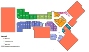
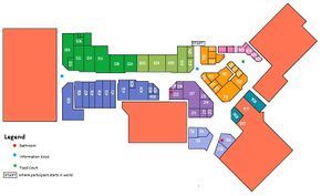
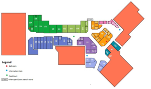
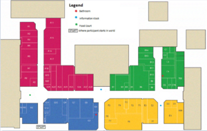
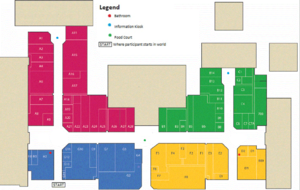
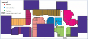
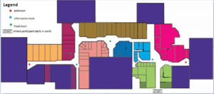
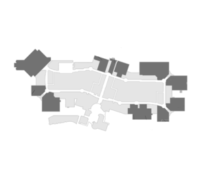
Three existing maps of shopping centres will be used as models for the environment. These base maps have been obtained from three different mall floor plans. Each existing floor plan will be rearranged into two alternative configurations, called ‘worlds’, for a total of nine worlds (World 1.a, 1.b, 1.c, 2.a, 2.b, 2.c, 3.a, 3.b, 3.c). These alternative configurations will specifically vary the location of the Points of Interest (PoI). The PoIs for this study will include: two bathrooms, two information kiosks, and one food court, each represented by symbols specified in the legends. In the virtual environments, the PoI will not be labeled with signage and the participant will be left to locate the PoI based on intuition as well as trial and error. In each of the figures attached, the PoI are marked as the following: red dots for the bathroom, blue dots for the information kiosks and a green dot for the food court. Where the participant starts in the virtual environment is marked on each map with a START. Each of the base worlds have very different layouts, allowing for more diverse results. The participant will start at an entrance to the shopping centre and will make their way through the floor plan, looking for the five PoI.
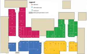
There will be three rooms used for the experiment. Each room will be equipped with a VR headset and treadmill, a principal researcher and two assistants. The participant will arrive and be given 15 minutes to acclimatize to the virtual environment. The acclimatization process will involve being set up with a VR headset and treadmill to practice a walkthrough of the test environment, specifically showing their ability to walk comfortably through environment, turn corners with use of the treadmill, and open doors. The test world blueprint can be seen below (World 4). The test environment will not contain PoI, or any other details. It will be a simple layout of a shopping centre. The acclimatization world will be a separate floor plan entirely to the ones being used in the experiment.
After passing the acclimatization test, the participant will remain in the setup and a research assistant will start the first world. Each participant will be randomly assigned one world from each original blueprint (three total). The participant will be given 15 minutes in each environment to locate the PoI, totaling to 45 minutes spent in the virtual environment (excluding acclimatization). The order of the worlds will be the same for each participant, starting with World 1, World 2, and ending with World 3.
As discussed previously, there will be no signage to assist in locating each PoI in the virtual environment. The participant will only know if they have found a PoI once they have walked directly to one. The PoI will not be distinguishable from a distance i.e. the participant will have to walk to the area to find out if they have located the food court, not be able to locate it by looking down the hall.
Once a PoI has been located, the position will be marked with a star in the environment for the participant to see and the time elapsed and route taken will be recorded. Once the participant has found all PoI, or after 15 minutes, the research assistant will put on the next world. Once all three worlds have been completed, the equipment will be removed and sanitized for the next participant. Providing an hour per participant, the experiment will take place over 4 days with 25 participants per day.
The data from this experiment will be documented in two ways. For each participant, the time taken between finding each PoI will be recorded. For each world, this time data will be averaged together. The routes taken to get to each PoI will also be recorded and the mean obtained (in meters). Together, this data will be used to rank each world according to efficiency, relating to time elapsed and paths taken. The worlds will be ranked three different ways. The first ranking will simply be time elapsed between the location of each PoI. This ranking will be based on time and speed to create a fair comparison of each participant's ability to locate the PoI. The second ranking will be based on routes taken. Longer routes to find PoI will result in a lower ranking. Lastly, the third ranking will be a combination of the two. This ranking will encompass both time/speed as well as routes taken, to provide an even more comprehensive comparison of each world's efficiency. Commonly missed PoI will also be factored into the ranking of the worlds. This data will provide useful insight for building developers regarding the ideal placement of various PoI to result in more intuitive layouts, ultimately reducing confusion and maximizing efficiency. While this data is specific to shopping malls, due to the versatile nature of virtual reality, the experiment is an easy one to adapt to many other public spaces in order to obtain wayfinding information.
Budget
This experiment will require a moderate up-front investment. However, all equipment can be amortized over future studies. The current retail price of the HTC Vive is $799 CAD. The required CPU and graphics card should cost approximately $400 CAD and $900 CAD, respectively. The cost of a single computer should be around $2000 each. These PCs will be bought pre-built from a reputable computer company (e.g. Dell or HP) that specialize in VR Ready hardware. This way, it saves manual labour work and time from building them ourselves.
There is no direct price for the Virtuix Omni gear (the VR-Ready treadmill) but the estimate is $700 for each station. This would include the harness, platform, and VR shoes. The Unity engine can be used for free, with different pricing schedules for various perks. This study should not require anything beyond the free or $35/month plans. The real cost are the developers that will create each mall scenario. A project of this scale can cost around $20,000 - $30,000, especially for an experienced VR developer. Co-op students will considered for this project as a short commitment is required. The developer(s) will create a template of each of the three worlds and create assets for each Pol. From there, the experimenters can change or move a PoI as they wish. Thus, the upfront cost may be high, but the experimenters are able to have immense flexibility to change the layout of the mall as they wish. This would cost exponentially more if it was done in real life.
Discussion
This experimental approach was selected for its level of control, versatility, and potential for widespread use. Virtual spaces, like the ones used in this experiment, can be modified or completely changed to examine the effects on navigability. This allows any researcher to determine the effect of any specific structure in any specific location, rather than having to rely on indirect comparisons between collections of similar spaces in the material world. This experimental approach will also permit extension into the design of other spaces, such as airports, hospitals, or even exterior locations such as outdoor festivals or theme parks. The only changes needed would be the design and assembly of new environments, many of which could be completely or partially composed of recycled elements. If effective, this method of testing environments could completely change the method by which buildings are designed. Rather than attempting to apply the constantly-evolving body of knowledge concerning wayfinding to new designs, architects and engineers can simply test and tweak their designs. The virtual trial-run of an environment would remove nearly all uncertainty. This would dramatically reduce the risk connected to new and innovative layouts, as designers could be confident that their plan will be effective well before construction has even begun. Thus, this proposed study could provide significant benefit to both academic and commercial enterprise.
Anticipated Results
It is predicted that there will be significant differences in the navigation time between versions of worlds, and possibly between world types as well. These differences will indicate that some variations of the maps are easier to navigate, and some are more difficult. This will also indicate that participants abilities to navigate are effectively challenged or facilitated by manipulations of virtual space. It is also expected that some features of the maps will enable navigation, while others will hinder it. These features could include structure proximity, adjacency, lines of visibility, corners, hallways, and more. When comparing the times and routes, it is expected that trends can be identified and connected to these features or patterns thereof. These additional findings could be used to construct improved layouts, which could be tested and compared to each other and previous results. These findings could then be taken to construct even more efficient layouts. This iterative process is an example of how this experimental design would empower designers to optimize their work.
Evaluation
Success for this project can be described in regard to several different facets, namely the immersivity, the resultant data, and the usefulness of the data.
For the purposes of obtaining useful data, it is important that the participants feel they are in an environment with some degree of realism. Though for the purposes of wayfinding, it is not necessary for the experience be indistinguishable from reality, nor even that it be particularly beautiful. However, it is essential that the environments seem real in the aspect of their existence as distinct spaces to be explored. The participants should feel that the virtual space is coherent and navigable. Note that by navigable, it is meant that this space can be navigated at all - that participants are able to distinguish space, walls, floors, and architectural features. They must also be able to make sense of their position and orientation within this space, to the extent that they can move within the space without undue disorientation. These outcomes could be determined before this proposal’s experiment using a small preliminary study, or within this experiment by use of post-experiment interviews or surveys.
The data itself will be a useful metric for the success of this proposed study. Both the time taken to complete the maps and the routes themselves will demonstrate the efficacy of this work. It is expected that there will be a distinct pattern to the navigation times when comparing maps. This would indicate that manipulating the environment was having a measurable effect on navigability. If the times do not coalesce into any discernible trend, this results would become more complex. This could indicate that the experiment itself does not reflect or adequately measure wayfinding ability or the difficulty of navigating through unfamiliar space. However, it could also indicate that the chosen PoI and their locations were simply not rearranged in a meaningfully different manner. This interpretation would indicate the need for future research. The results of the routes taken by participants would be interpreted similarly to those of the times. Clear patterns of both the path of the routes and their lengths would indicate specific impacts of the environment on the participants’ wayfinding ability. Disorganized results for these routes could indicate poorly manipulated PoI or a failure of the test to measure wayfinding. Inconclusive data from routes or times could also be explained in a third manner, that the environments themselves did not offer enough visual cues for participants to interpret in a reliable manner.
The final test of this study would be in the application of its process. If the previously mentioned tests passed, it would be possible to use that data to create new environments based upon the traits of the fastest ones from the previous trial. This could be done by either randomly altering the most effective layouts, or applying any insights from the commonalities of the most efficient worlds. If improvements were made after this iterative process was conducted, this study would be unequivocally successful. This would indicate that the study was able to determine features of an effective layout and exploit that information to improve designs. A measurable improvement to a building navigability through careful manipulation of PoI would be the ultimate outcome as a proof of concept, method to study wayfinding, and potential industry tool.
Conclusion
The past months working on this project have been very enlightening concerning the research process and the field of COGS. Our project was illuminating from the moment we met together to brainstorm research directions. Despite none of us being familiar with each other, we managed to generate at least a dozen excellent ideas, connecting Philosophy, Computer Science, Psychology, and Linguistics in new and exciting ways. The multidisciplinary composition of our group was undoubtedly a key factor in this early success. The true strength of this arrangement was not apparent before we began. Not only did we have each discipline represented, which was essential, but we all had something unique to bring to the group. This allowed each of us to exercise our knowledge and experience, emboldened by our position as the resident expert. Once our direction had been decided upon, we were all surprised to find that there was already a wealth of relevant information in this area, despite the specificity of this work. Not only did we find more information concerning wayfinding than we could possibly read, but even a small body of research that was already incorporating VR in this pursuit. Indeed, it appears that the fields of Computer Science and Psychology have been significantly intertwined for decades or longer. None of us would have predicted the extent to which this area had become interdisciplinary. Another key insight came from our initial proposal. We had presumed our proposal to be well-designed and relatively ironclad. However, several probing questions that night and comments on Canvas indicated significant problems. It seems that even with preparation, it is difficult, if not impossible to predict all of the potential flaws or confounds in an experiment. A small group of people, no matter how careful, will undoubtedly always have blind-spots. This certainly gives a new appreciation for the importance of peer-review. When addressing these concerns, we realised that tinkering with a complex research design with many different components was no simple task. It seemed that every small change would invariably impact some other area of the proposal. In a way, a developing project is like a neural net. Every node is connected and small adjustments to any will have significant impacts on the whole.
At the inception of this project, none of us could confidently say just what COGS actually was or exactly the type of research it entailed. However, as we went through the process of creating our own proposal and hearing those of others, it all began to make sense. It seems that COGS exists at the edges of these disciplines, where they run together. The field exists to research those areas that do not quite fit in exactly one of these disciplines, but deserve dedicated inquiry nonetheless. The proposals of other groups were as enlightening as our own. Not one of the proposals we heard from other groups was like another. It is clear that the multidisciplinary nature of COGS allows for an incredibly diverse array of research directions. That said, we did notice that a disproportionate number of proposals were aligned to the Psychology-Computer Science axis. Possibly this is due to our collective familiarity with these subjects relative to Linguistics and Philosophy. With advanced technology now ubiquitous and our “folk psychology” close at hand, even people unfamiliar with the formal study of these disciplines can feel that they are on steady ground. This could alternatively be related to the incredible rate of computer technology development, which has defined this century and captured our collective imaginations. Additionally, the study of Psychology contains a myriad of subfields and a breadth spanning from Biology and Chemistry to Sociology and Economics, just to name a few of its borders. This makes for a wealth of research possibilities, allowing expertise from even more disciplines to help generate ideas.
Overall, this project has been an exciting and informative sojourn into the field of COGS and academic research. The strengths of our multidisciplinary team from which we benefited were a useful analogy to understand the field of COGS itself. The combination of different fields enabled us to ask questions and plan projects unlike anything that came before.
Appendix: First Proposal
This study will use virtual reality to evaluate and optimize the internal architecture of shopping malls. Specifically it will explore various placements of important architectural features. The results of this study can be used to create more intuitive layouts for shopping malls that aim to reduce confusion and enhance efficiency.
To conduct this study, ~100 participants between the ages of 18 to 50 will be used from a broad population sample. Three existing blueprints will be used as models for the environment. Each existing floor plan will be rearranged into two alternative configurations, called ‘worlds’, for a total of nine worlds. Each world will specifically vary the location of various Points of Interest (PoI). The PoIs for this study will include: bathrooms, emergency exits, and the food court.
Each participant will be randomly assigned one world from each original blueprint (three total). Using a head mounted display and a virtual reality treadmill (allowing for a more realistic experience), the participants will navigate through the various worlds, locating points of interest. The time and route used to find each point of interest will be recorded. The data will be averaged and the worlds will be ranked according to efficiency.
This study incorporates elements from computer science and psychology. Computer science techniques will drive the mechanisms of this study including world design, data collection, and data analysis. The focus of the study is Psychologically based; wayfinding strategies and human interaction with environment fall within fields of cognitive, behavioural, and environmental psychology.
Bibliography
Carpman, J. R., & Grant, M. A. (2001). Design that cares: Planning health facilities for patients and visitors (2 ed.). New York: Jossey-Bass.
Carpman, J. R., & Grant, M. A. (2002). Wayfinding: A broad view. In R. B. Bechtel & A. Churchman (Eds.), Handbook of environmental psychology (1st ed., pp. 427–442) New York: Wiley & Sons.
Cubukcu, E., & Nasar, J. L. (2005). Influence of physical characteristics of routes on distance cognition in virtual environments. Environment and Planning B: Planning and Design, 32(5), 777–785.
Wilson, Christopher J., & Soranzo, Alessandro (2015). The use of virtual reality in psychology: a case study in visual perception. Computational and Mathematical Methods in Medicine, 2015, 1-7. doi:10.1155/2015/151702
This study compared vertical and horizontal signage systems and it found that horizontal conditioned individuals traveled smaller distances, traveled faster, and spent less time finding places. We can use this study to incorporate horizontal conditioning into our project.
Gärling, T., Lindberg, E., & Mäntylä, T. (1983). Orientation in buildings: Effects of familiarity, visual access, and orientation aids. Journal of Applied Psychology, 68(1), 177–186.
Hölscher, C., Meilinger, T., Vrachliotis, G., Brösamle, M., & Knauff, M. (2006). Up the down staircase: Wayfinding strategies in multi-level buildings. Journal of Environmental Psychology, 26(4), 284-299. doi:10.1016/j.jenvp.2006.09.002
This study demonstrated that for participants who were unfamiliar with the environment, unique landmarks and points of interest were crucial for wayfinding. It also presented a useful list of measures to evaluate wayfinding efficacy: time, stops, getting lost, distance, route, and speed.
Hölscher, C., Büchner, S. J., Meilinger, T., & Strube, G. (2009). Adaptivity of wayfinding strategies in a multi-building ensemble: The effects of spatial structure, task requirements, and metric information. Journal of Environmental Psychology,29(2), 208-219. doi:10.1016/j.jenvp.2008.05.010
This study assessed the wayfinding techniques of people, varying their environments and the participants’ familiarity with them. They showed that the environment itself was a stronger predictor of strategy choice than any other factor. This indicates that our study, which specifically manipulates the environment, should yield useful data.
Morganti, F., Carassa, A., & Geminiani, G. (2007). Planning optimal paths: A simple assessment of survey spatial knowledge in virtual environments. Computers in Human Behavior, 23(4), 1982–1996.
Negut, A., Matu, S., Sava, F. A., & David D. (2015). Convergent validity of virtual reality neurocognitive assessment: a meta-analytic approach. Transylvanian Journal Of Psychology, 16(1), 31-55.
This study used a meta-analytic approach to demonstrate that virtual reality has significant convergent validity to traditional psychological measures. In short, VR is capable of of eliciting the same behaviours and cognitions as traditional experimental methods.
Rooke, C., Koskela, L., & Tzortzopoulos, P. (2010). Achieving a lean wayfinding system in complex hospital environments: Design and through-life management. Paper presented at the 18th Annual Conference of the International Group for Lean Construction, July 14–16, 2010, Haifa, Israel. Retrieved from http://usir.salford.ac.uk/9552/
Zhong, C., Liu, S., Lu, Q., Zhang, B., & Yang, S. X. (2016). An Efficient Fine-to-Coarse Wayfinding Strategy for Robot Navigation in Regionalized Environments. IEEE Transactions on Cybernetics,46(12), 3157-3170. doi:10.1109/tcyb.2015.2498760
Describes and tests a new wayfinding algorithm for robots. It effectively outlines another important reason for studying human wayfinding and searching processes. The most effective strategies for robots are those modeled after human tactics.
